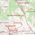
File:Ländchesbahn-Karte.png
Appearance

Size of this preview: 609 × 599 pixels. Other resolutions: 244 × 240 pixels | 488 × 480 pixels | 781 × 768 pixels | 1,041 × 1,024 pixels | 1,600 × 1,574 pixels.
Original file (1,600 × 1,574 pixels, file size: 1.36 MB, MIME type: image/png)
File history
Click on a date/time to view the file as it appeared at that time.
| Date/Time | Thumbnail | Dimensions | User | Comment | |
|---|---|---|---|---|---|
| current | 19:20, 6 December 2014 |  | 1,600 × 1,574 (1.36 MB) | Geostba | == {{int:filedesc}} == {{OpenStreetMap |description = {{en|This map shows the track of Ländches Railway with its stations Wiesbaden Hbf, Erbenheim, Igstadt, Auringen-Medenbach and Niedersachsen. Other railway lines: [[:en:Aar... |
File usage
The following page uses this file:
Global file usage
The following other wikis use this file:
- Usage on de.wikipedia.org
- Usage on www.wikidata.org

