
File:Kataja-en.svg

Size of this PNG preview of this SVG file: 557 × 599 pixels. Other resolutions: 223 × 240 pixels | 446 × 480 pixels | 714 × 768 pixels | 952 × 1,024 pixels | 1,904 × 2,048 pixels | 1,134 × 1,220 pixels.
Original file (SVG file, nominally 1,134 × 1,220 pixels, file size: 31 KB)
| This is a file from the Wikimedia Commons. Information from its description page there is shown below. Commons is a freely licensed media file repository. You can help. |
Summary
| Description |
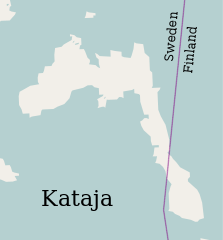
English: Map of the islet of Kataja, divided between Sweden and Finland. |
| Date | (UTC) |
| Source |
This file was derived from: Катая.svg:  |
| Author |
| This is a retouched picture, which means that it has been digitally altered from its original version. Modifications: Translated to English. The original can be viewed here: Катая.svg:
|
Licensing
I, the copyright holder of this work, hereby publish it under the following license:
This file is licensed under the Creative Commons Attribution-Share Alike 2.0 Generic license.
- You are free:
- to share – to copy, distribute and transmit the work
- to remix – to adapt the work
- Under the following conditions:
- attribution – You must give appropriate credit, provide a link to the license, and indicate if changes were made. You may do so in any reasonable manner, but not in any way that suggests the licensor endorses you or your use.
- share alike – If you remix, transform, or build upon the material, you must distribute your contributions under the same or compatible license as the original.
Original upload log
This image is a derivative work of the following images:
- File:Катая.svg licensed with Cc-by-sa-2.0
- 2010-12-11T15:41:26Z Insider 1134x1220 (31870 Bytes) == Summary == {{ru|1=Остров Катая}} {{OpenStreetMap}} [[Category:Islands of Finland]] [[Category:Islands of Sweden]] [[Category:Islands of the Baltic Sea]] [[Category:International islands]]
Uploaded with derivativeFX
File history
Click on a date/time to view the file as it appeared at that time.
| Date/Time | Thumbnail | Dimensions | User | Comment | |
|---|---|---|---|---|---|
| current | 13:20, 18 August 2012 | | 1,134 × 1,220 (31 KB) | Antilope | == {{int:filedesc}} == {{Information |Description=Map of the islet of Kataja, divided between Sweden and Finland. |Source={{Derived from|Катая.svg|display=50}} |Date=2012-08-18 12:58 (UTC) |Author=*File:Катая.svg: OpenStree... |
File usage
The following page uses this file:
Global file usage
The following other wikis use this file:
- Usage on be.wikipedia.org
- Usage on ceb.wikipedia.org
- Usage on da.wikipedia.org
- Usage on de.wikipedia.org
- Usage on es.wikipedia.org
- Usage on eu.wikipedia.org
- Usage on fi.wikipedia.org
- Usage on fr.wikipedia.org
- Usage on hr.wikipedia.org
- Usage on it.wikipedia.org
- Usage on ko.wikipedia.org
- Usage on lv.wikipedia.org
- Usage on no.wikimedia.org
- Prosjekt:Undervisningspilot Samisk kunnskap på nett/Oppgave 1
- Prosjekt:Undervisningspilot Samisk kunnskap på nett/Oppgave 1/Steder i finsk Lappland
- Prosjekt:Samisk kunnskap på nett/Undervisning/For studenter/Oppgave 1/Steder i finsk Lappland
- Prosjekt:Undervisningspilot Samisk kunnskap på nett/Oppgave 1/nb
- Prosjekt:Undervisningspilot Samisk kunnskap på nett/Oppgave 1/se
- Usage on pl.wikipedia.org
- Usage on ro.wikipedia.org
- Usage on www.wikidata.org