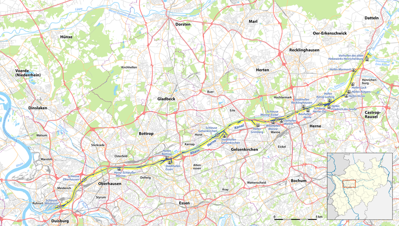
File:Karte des Rhein-Herne-Kanals.png
Appearance

Size of this preview: 800 × 453 pixels. Other resolutions: 320 × 181 pixels | 640 × 362 pixels | 1,024 × 579 pixels | 1,280 × 724 pixels | 2,352 × 1,331 pixels.
Original file (2,352 × 1,331 pixels, file size: 1.4 MB, MIME type: image/png)
File history
Click on a date/time to view the file as it appeared at that time.
| Date/Time | Thumbnail | Dimensions | User | Comment | |
|---|---|---|---|---|---|
| current | 18:49, 5 February 2012 |  | 2,352 × 1,331 (1.4 MB) | NordNordWest | upd |
| 19:24, 13 December 2011 |  | 2,352 × 1,331 (2.25 MB) | NordNordWest | ||
| 19:39, 12 December 2011 |  | 2,352 × 1,331 (1.4 MB) | NordNordWest | == {{int:filedesc}} == {{Information |Description={{de|Karte des Rhein-Herne-Kanals}} |Author={{U|NordNordWest}} |Source={{own}} * OpenStreetMap data for the background * File:North Rhine-Westphalia location map 01.svg by TUBS f |
File usage
The following page uses this file:
Global file usage
The following other wikis use this file:
- Usage on de.wikipedia.org
- Usage on eo.wikipedia.org
- Usage on fr.wikipedia.org
- Usage on nl.wikipedia.org

