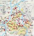
File:Karte Fichtelgebirge.png
Appearance

Size of this preview: 563 × 600 pixels. Other resolutions: 225 × 240 pixels | 451 × 480 pixels | 750 × 799 pixels.
Original file (750 × 799 pixels, file size: 886 KB, MIME type: image/png)
File history
Click on a date/time to view the file as it appeared at that time.
| Date/Time | Thumbnail | Dimensions | User | Comment | |
|---|---|---|---|---|---|
| current | 20:28, 28 July 2019 |  | 750 × 799 (886 KB) | Chianti | factual errors by original "research" |
| 10:33, 4 November 2011 |  | 750 × 799 (1.17 MB) | Schubbay | Tonwertkorrektur | |
| 20:14, 17 November 2010 |  | 750 × 799 (886 KB) | Uwe Dedering | less old jpg artefacts, same source, same map, permission should be valid | |
| 18:40, 14 April 2010 |  | 750 × 799 (1.01 MB) | Bermicourt | {{Information |Description={{de|''no original description''}} {{en|Map of main towns and villages in the Fichtelgebirge mountain range in Bavaria, Germany}} |Source=Transferred from [http://de.wikipedia.org de.wikipedia] |Date={{Date|2005|08|21}} (origina |
File usage
The following 2 pages use this file:
Global file usage
The following other wikis use this file:
- Usage on de.wikipedia.org
- Usage on de.wikivoyage.org
- Usage on lld.wikipedia.org
- Usage on ro.wikipedia.org
- Usage on www.wikidata.org
