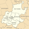
File:Kaart van Gauteng munisipaliteite (2011).svg
Appearance

Size of this PNG preview of this SVG file: 595 × 600 pixels. Other resolutions: 238 × 240 pixels | 476 × 480 pixels | 762 × 768 pixels | 1,016 × 1,024 pixels | 2,032 × 2,048 pixels | 754 × 760 pixels.
Original file (SVG file, nominally 754 × 760 pixels, file size: 223 KB)
File history
Click on a date/time to view the file as it appeared at that time.
| Date/Time | Thumbnail | Dimensions | User | Comment | |
|---|---|---|---|---|---|
| current | 14:50, 4 September 2011 |  | 754 × 760 (223 KB) | Htonl | {{Information |Description ={{en|1=Map of municipalities of w:Gauteng.}} {{af|1=Kaart van munisipaliteite van w:Gauteng.}} |Source ={{own}} |Author =Htonl |Date =2011-09-04 |Permission = |other_versi |
File usage
No pages on the English Wikipedia use this file (pages on other projects are not listed).
Global file usage
The following other wikis use this file:
- Usage on af.wikipedia.org
- Gauteng
- Stad Tshwane Metropolitaanse Munisipaliteit
- Ekurhuleni Metropolitaanse Munisipaliteit
- Sedibeng-distriksmunisipaliteit
- Stad Johannesburg Metropolitaanse Munisipaliteit
- Midvaal Plaaslike Munisipaliteit
- Wesrand-distriksmunisipaliteit
- Emfuleni Plaaslike Munisipaliteit
- Lesedi Plaaslike Munisipaliteit
- Mogale City Plaaslike Munisipaliteit
- Randfontein Plaaslike Munisipaliteit
- Westonaria Plaaslike Munisipaliteit
- Merafong City Plaaslike Munisipaliteit
- Sjabloon:Gauteng Munisipaliteite
- Gebruiker:Ossewa
- Sjabloon:Gebruiker Gauteng
- Rand West City Plaaslike Munisipaliteit
- Usage on nl.wikipedia.org

