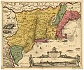
File:Jansson-Visscher map.jpg
Appearance

Size of this preview: 712 × 600 pixels. Other resolutions: 285 × 240 pixels | 570 × 480 pixels | 912 × 768 pixels | 1,215 × 1,024 pixels | 1,728 × 1,456 pixels.
Original file (1,728 × 1,456 pixels, file size: 2.67 MB, MIME type: image/jpeg)
File history
Click on a date/time to view the file as it appeared at that time.
| Date/Time | Thumbnail | Dimensions | User | Comment | |
|---|---|---|---|---|---|
| current | 14:07, 15 April 2018 |  | 1,728 × 1,456 (2.67 MB) | Hansmuller | Reverted to version as of 12:50, 30 July 2012 (UTC) |
| 12:57, 30 July 2012 |  | 496 × 418 (69 KB) | Joopr132 | Reverted to version as of 15:38, 3 December 2005 | |
| 12:50, 30 July 2012 |  | 1,728 × 1,456 (2.67 MB) | Joopr132 | Higher Resolution | |
| 15:38, 3 December 2005 |  | 496 × 418 (69 KB) | Laurascudder | The Jansson-Visscher map of en:New Netherland, first published in 1650. On the left are illustrations of typical indian villiages of several types, while the lower right inset shows a picture of New Amsterdam. See also [[:Image:Map-Novi Belgii Novæ |
File usage
The following page uses this file:
Global file usage
The following other wikis use this file:
- Usage on azb.wikipedia.org


