
File:Jan Karski missions en.png

Size of this preview: 800 × 566 pixels. Other resolutions: 320 × 226 pixels | 640 × 453 pixels | 1,024 × 724 pixels | 1,280 × 905 pixels | 2,560 × 1,810 pixels | 3,507 × 2,480 pixels.
Original file (3,507 × 2,480 pixels, file size: 2.83 MB, MIME type: image/png)
| This is a file from the Wikimedia Commons. Information from its description page there is shown below. Commons is a freely licensed media file repository. You can help. |
Summary
| Description |
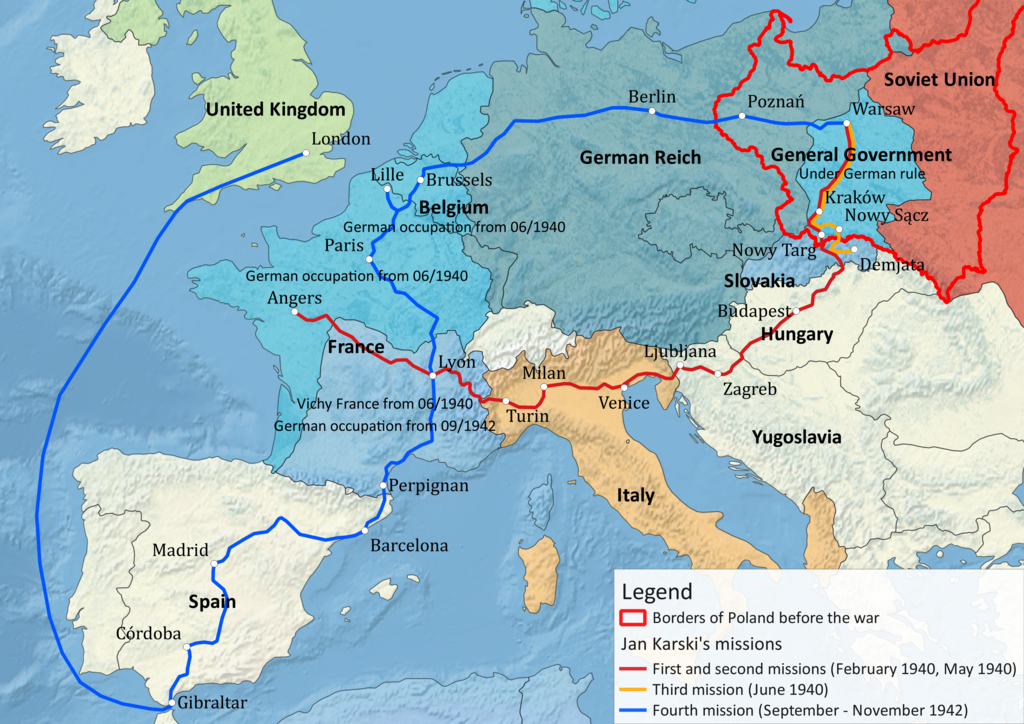
English: Jan Karski's missions |
| Date | |
| Source | Own work |
| Author | Antissimo |
| Permission (Reusing this file) |
Permission is granted for reuse under the terms of the Creative Commons licence specified below. The required attribution is: Antal Gertheis, 2014. I would appreciate a message on my talk page if you plan to reuse this image outside of Wikimedia projects. |
| Other versions |
|

Made with Natural Earth raster + vector data (PD [1])
Historical borders: 'European Territorial Changes During WWII' dataset [2], GeoCommons (CC BY 3.0) adapted to this specific map
Based on information from Jan Karski's missions 1940-1943 map by Polish History Museum and Google Cultural Institute, other historical maps in Wikimedia Commons, as well as written sources
Licensing
I, the copyright holder of this work, hereby publish it under the following license:
This file is licensed under the Creative Commons Attribution-Share Alike 3.0 Unported license.
Attribution: Antal Gertheis, 2014
- You are free:
- to share – to copy, distribute and transmit the work
- to remix – to adapt the work
- Under the following conditions:
- attribution – You must give appropriate credit, provide a link to the license, and indicate if changes were made. You may do so in any reasonable manner, but not in any way that suggests the licensor endorses you or your use.
- share alike – If you remix, transform, or build upon the material, you must distribute your contributions under the same or compatible license as the original.
File history
Click on a date/time to view the file as it appeared at that time.
| Date/Time | Thumbnail | Dimensions | User | Comment | |
|---|---|---|---|---|---|
| current | 14:49, 3 June 2014 | | 3,507 × 2,480 (2.83 MB) | Antissimo | data correction (year) |
| 13:11, 3 June 2014 |  | 3,507 × 2,480 (2.83 MB) | Antissimo | User created page with UploadWizard |
File usage
The following page uses this file:
Global file usage
The following other wikis use this file:
- Usage on ca.wikipedia.org
- Usage on el.wikipedia.org
- Usage on eo.wikipedia.org
- Usage on no.wikipedia.org
- Usage on pl.wikipedia.org
- Usage on sk.wikipedia.org