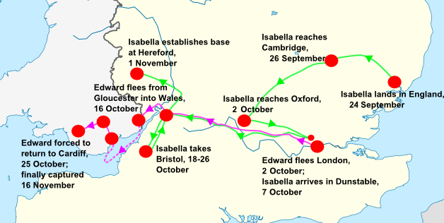
File:Isabella's invasion route (1326).png
Appearance
Isabella's_invasion_route_(1326).png (628 × 316 pixels, file size: 94 KB, MIME type: image/png)
File history
Click on a date/time to view the file as it appeared at that time.
| Date/Time | Thumbnail | Dimensions | User | Comment | |
|---|---|---|---|---|---|
| current | 21:08, 5 July 2018 |  | 628 × 316 (94 KB) | John | Fixed date formats |
| 06:41, 15 April 2010 |  | 628 × 316 (81 KB) | Hchc2009 | {{Information |Description={{de|Positionskarte von England}} Quadratische Plattkarte, N-S-Streckung 170 %. Geographische Begrenzung der Karte: * N: 56.0° N * S: 49.75° N * W: 6.75° W * O: 2.0° O {{en|Location map of [[:en:England|En |
File usage
No pages on the English Wikipedia use this file (pages on other projects are not listed).
Global file usage
The following other wikis use this file:
- Usage on da.wikipedia.org
- Usage on id.wikipedia.org
- Usage on no.wikipedia.org

