I, Vishwin60, the creator of this image, hereby release it into the public domain. If that cannot be done for any reason, including the nonexistence of a way to release a work into the public domain, I release it (or my changes in the case of a derivative work) under the following licenses:
Copyleft: This work of art is free; you can redistribute it and/or modify it according to terms of the Free Art License. You will find a specimen of this license on the Copyleft Attitude site as well as on other sites. http://artlibre.org/licence/lal/enFALFree Art Licensefalsetrue
The copyright holder of this work allows anyone to use it for any purpose including unrestricted redistribution, commercial use, and modification.
Please check the source to verify that this is correct. In particular, note that publication on the Internet, like publication by any other means, does not in itself imply permission to redistribute. Files without valid permission should be tagged with {{subst:npd}}.
Usage notes:
If the work requires attribution, use {{Attribution}} instead.
If this is your own work, please use {{Cc-zero}} instead.
This file is licensed under Creative CommonsShareAlike 1.0 License.
Creative Commons has retired this legal tool and does not recommend that it be applied to works.
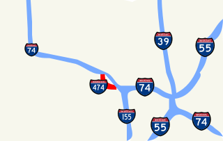
{{Information |Description=Map of I-474 in Peoria, Illinois |Source=Own work |Date=January 12, 2007 |Author=Vishwin60 |Permission=Public domain or other licenses |other_versions= }} == Licensing == {{vsh60lic}}


_map_closeup_labeled.svg&lang=en)

_map_closeup_labeled.svg)
_map.svg)

