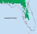
File:Interglacial Florida.png
Appearance

Size of this preview: 599 × 600 pixels. Other resolutions: 240 × 240 pixels | 479 × 480 pixels | 799 × 800 pixels.
Original file (799 × 800 pixels, file size: 224 KB, MIME type: image/png)
File history
Click on a date/time to view the file as it appeared at that time.
| Date/Time | Thumbnail | Dimensions | User | Comment | |
|---|---|---|---|---|---|
| current | 15:34, 11 January 2010 |  | 799 × 800 (224 KB) | Noles1984~commonswiki | Redoing upload. 2nd file was an error. This is the accurate file. Same author as original. Map based on State of Florida maps. http://www.flheritage.com/facts/reports/contexts/paleo.cfm and U. of Florida, Florida Geologic Survey, Tallahassee, 1994, ISS |
| 15:26, 11 January 2010 |  | 637 × 600 (111 KB) | Noles1984~commonswiki | Better representation and includes counties. | |
| 20:28, 27 November 2009 |  | 637 × 600 (111 KB) | Noles1984~commonswiki | {{Information |Description={{en|1=Map of interglacial Florida}} |Source={{own}} |Author=Noles1984 |Date=2009-09-29 |Permission= |other_versions= }} Category:Maps Category:Climate Category:Florida |
File usage
The following 9 pages use this file:
- Gadsden County, Florida paleontological sites
- Haile Quarry site
- Jefferson County, Florida paleontological sites
- Leon County, Florida paleontological sites
- Polk County, Florida paleontological sites
- Suwannee County, Florida paleontological sites
- Thomas Farm Site
- User:Noles1984/Sandbox2
- User:Noles1984/Sandbox5
