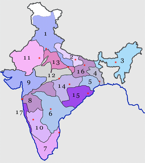
File:Indianrailwayzones-numbered.png
Appearance
Indianrailwayzones-numbered.png (500 × 563 pixels, file size: 33 KB, MIME type: image/png)
File history
Click on a date/time to view the file as it appeared at that time.
| Date/Time | Thumbnail | Dimensions | User | Comment | |
|---|---|---|---|---|---|
| current | 14:39, 17 June 2005 |  | 500 × 563 (33 KB) | Nichalp | Numbered map of the Indian Railways network: See w:Indian Railways ---- Map made by me, ~~~ ---- {{GFDL}} ---- category:Indian Railways category:Maps of India |
File usage
The following 22 pages use this file:
- Ajmer railway division
- Bikaner railway division
- Central Railway zone
- East Central Railway zone
- East Coast Railway zone
- Eastern Railway zone
- Indian Railways organisational structure
- Jaipur railway division
- Jodhpur railway division
- North Central Railway zone
- North Eastern Railway zone
- North Western Railway zone
- Northeast Frontier Railway zone
- Northern Railway zone
- Rail transport in Haryana
- South Central Railway zone
- South East Central Railway zone
- South Eastern Railway zone
- South Western Railway zone
- Southern Railway zone
- West Central Railway zone
- Western Railway zone
Global file usage
The following other wikis use this file:
- Usage on as.wikipedia.org
- Usage on bn.wikipedia.org
- Usage on fa.wikipedia.org
- Usage on hi.wikipedia.org
- Usage on kn.wikipedia.org
- Usage on mai.wikipedia.org
- Usage on ml.wikipedia.org
- Usage on mr.wikipedia.org
View more global usage of this file.


