File:Indiana civil war map.jpg
Appearance
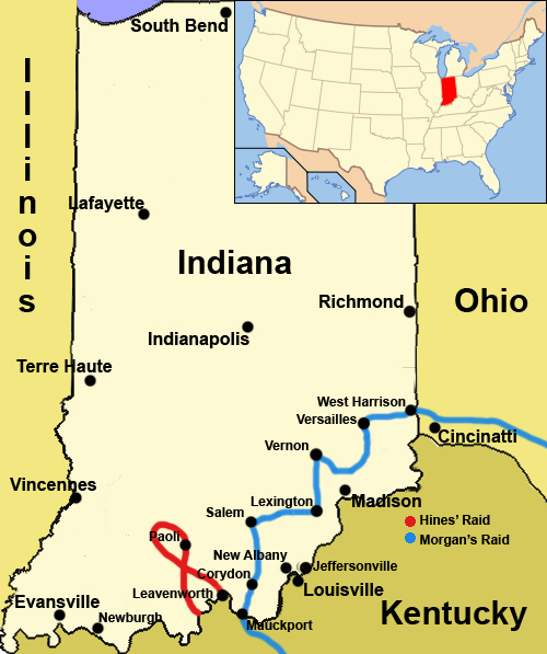
Indiana_civil_war_map.jpg (500 × 597 pixels, file size: 214 KB, MIME type: image/jpeg)
File history
Click on a date/time to view the file as it appeared at that time.
| Date/Time | Thumbnail | Dimensions | User | Comment | |
|---|---|---|---|---|---|
| current | 22:09, 22 October 2008 |  | 500 × 597 (214 KB) | Charles Edward | {{Information |Description=Remove one location, add another, shrink some text |Source=User Charles Edward |Date=10-22-08 |Author=Charles Edward |Permission={{pd-self}} |other_versions= }} Category:Maps of indiana |
| 21:44, 22 October 2008 |  | 500 × 597 (215 KB) | Charles Edward | {{Information |Description=Add two more locations, shrink font of lesser importance cities |Source=User Charles Edward |Date=10-22-08 |Author=Charles Edward |Permission={{pd-self}} |other_versions= }} Category:Maps of indiana | |
| 21:29, 22 October 2008 |  | 500 × 599 (219 KB) | Charles Edward | {{Information |Description=two typos, and changing to a smoother font |Source=User Charles Edward |Date=10-22-08 |Author=Charles Edward |Permission={{pd-self}} |other_versions= }} Category:Maps of indiana | |
| 21:16, 22 October 2008 |  | 500 × 599 (212 KB) | Charles Edward | {{Information |Description=enhanced version, better colours, lines, large map for context |Source=User Charles Edward |Date=10-22-08 |Author=Charles Edward |Permission={{pd-self}} |other_versions= }} Category:Maps of indiana | |
| 15:52, 18 June 2008 |  | 512 × 800 (184 KB) | Cool10191 | {{Information |Description=map of indiana in the civil war |Source= |Date= |Author= |Permission={{pd=self}} |other_versions= }} Category:Maps of indiana | |
| 15:45, 18 June 2008 |  | 512 × 800 (183 KB) | Cool10191 | {{Information |Description=map of indiana in the american civil war |Source= |Date=06-18-2008 |Author= |Permission={{pd-self}} |other_versions= }} Category:Maps of indiana | |
| 15:46, 17 June 2008 |  | 512 × 800 (243 KB) | Cool10191 | {{Information |Description=map of Indiana during the American civil war |Source= |Date= |Author=user:cool10191 |Permission={{pd-self}} |other_versions= }} Category:Maps of indiana | |
| 13:19, 17 June 2008 |  | 512 × 800 (236 KB) | Cool10191 | {{Information |Description={{en|1=A map of cities and activities in Indiana during the American Civil War}} |Source=Own work by uploader |Author=Cool10191 |Date=6-17-2008 |Permission={{pd-self}} |other_versions= }} {{ImageUpload|full}} |
File usage
The following 4 pages use this file:
Global file usage
The following other wikis use this file:
- Usage on fr.wikipedia.org
- Usage on it.wikipedia.org

