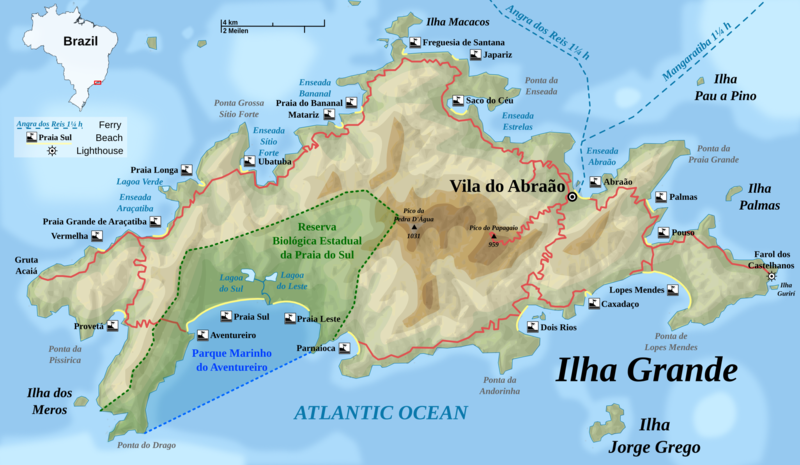
File:Ilha Grande topographic map-EN.png
Appearance

Size of this preview: 800 × 465 pixels. Other resolutions: 320 × 186 pixels | 640 × 372 pixels | 1,024 × 596 pixels | 1,280 × 745 pixels | 2,052 × 1,194 pixels.
Original file (2,052 × 1,194 pixels, file size: 1.52 MB, MIME type: image/png)
File history
Click on a date/time to view the file as it appeared at that time.
| Date/Time | Thumbnail | Dimensions | User | Comment | |
|---|---|---|---|---|---|
| current | 08:12, 5 July 2009 |  | 2,052 × 1,194 (1.52 MB) | Rosso Robot | a few corrections |
| 16:30, 4 July 2009 |  | 2,052 × 1,194 (1.52 MB) | Rosso Robot | {{Information |Description={{en|1=Detailed topographic map in Englisch of Ilha Grande}} {{de|1=Topografische Karte der Ilha Grande, englische Version}} Carte topographique détaillée en anglais de l'[[:fr:Ilha Gran |
File usage
The following page uses this file:
Global file usage
The following other wikis use this file:
- Usage on da.wikipedia.org
- Usage on en.wikivoyage.org
- Usage on es.wikipedia.org
- Usage on fi.wikipedia.org
- Usage on hr.wikipedia.org
- Usage on hy.wikipedia.org
- Usage on it.wikipedia.org
- Usage on ko.wikipedia.org
- Usage on lt.wikipedia.org
- Usage on ru.wikipedia.org
- Usage on tr.wikipedia.org
- Usage on vi.wikipedia.org
- Usage on zh.wikipedia.org


