Jump to content

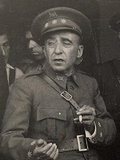
File:Ildefonso Puigdengolas (Albero y Segovia 21-07-1936) en Alcalá de Henares.png

Page contents not supported in other languages.
This is a file from the Wikimedia Commons
From Wikipedia, the free encyclopedia

Original file (1,126 × 831 pixels, file size: 1.25 MB, MIME type: image/png)

Summary

Photographer
Félix Albero Trullen  (1894–1964) wikidata:Q125761159
 
Description Spanish photographer
Date of birth/death 1894 Edit this at Wikidata 1964 Edit this at Wikidata
Authority file
creator QS:P170,Q125761159
Francisco Segovia García  (1901–1975) wikidata:Q125761198
 
Description Spanish photographer
Date of birth/death 1901 Edit this at Wikidata 1975 Edit this at Wikidata
Authority file
creator QS:P170,Q125761198
Title
Español: El coronel Puigdengolas en la puerta del Ayuntamiento de Alcalá de Henares, dando órdenes para que saliesen fuerzas hacia Guadalajara. Acompañado por el concejal socialista Simón García de Pedro y un oficial de aviación el 21 de julio de 1936, tras la rendición de los militares rebeldes en Alcalá de Henares (Comunidad de Madrid - España).
Depicted people Ildefonso Puigdengolas (Q4890774)
Depicted place Alcalá de Henares
Date 21 July 1936
date QS:P571,+1936-07-21T00:00:00Z/11
Archivo General de la Administración
Current location
Archivo Fotográfico de la Delegación de Propaganda y Prensa de Madrid durante la Guerra Civil (Archivo Rojo)
Accession number
Notes Categoría: Escenas de guerra (Archivo Rojo), Primeros momentos de la Rebelión
Source PARES
Permission
(Reusing this file)
Public domain

The author died in 1936, so this work is in the public domain in its country of origin and other countries and areas where the copyright term is the author's life plus 80 years or fewer.


You must also include a United States public domain tag to indicate why this work is in the public domain in the United States.
This file has been identified as being free of known restrictions under copyright law, including all related and neighboring rights.
Other versions
Camera location40° 28′ 54.52″ N, 3° 21′ 51.46″ W Kartographer map based on OpenStreetMap.View this and other nearby images on: OpenStreetMapinfo

Captions

Add a one-line explanation of what this file represents

40°28'54.520"N, 3°21'51.462"W

image/png

File history

Click on a date/time to view the file as it appeared at that time.

Date/TimeThumbnailDimensionsUserComment
current15:37, 11 September 2016Thumbnail for version as of 15:37, 11 September 20161,126 × 831 (1.25 MB)Raimundo PastorUser created page with UploadWizard

The following page uses this file:

Global file usage

The following other wikis use this file:

Metadata