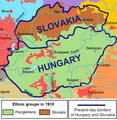
File:Hu-sk-1910enthnographics-with-current-borders.png
Appearance
Hu-sk-1910enthnographics-with-current-borders.png (527 × 539 pixels, file size: 117 KB, MIME type: image/png)
File history
Click on a date/time to view the file as it appeared at that time.
| Date/Time | Thumbnail | Dimensions | User | Comment | |
|---|---|---|---|---|---|
| current | 06:49, 8 October 2023 |  | 527 × 539 (117 KB) | OrionNimrod | Restore, notorious fake map creater and blocked user on wikipedia removed Hungarians from the map |
| 16:18, 9 April 2019 |  | 527 × 539 (120 KB) | Julieta39 | Cosmetic since [https://fr.wikipedia.org/wiki/Emmanuel_de_Martonne#/media/File:MittelEuropa1914.JPG] | |
| 15:41, 2 December 2017 |  | 527 × 539 (117 KB) | Mélomène | Towns | |
| 21:50, 22 August 2009 |  | 527 × 539 (109 KB) | Qorilla | {{Information |Description={{en|1=Present day borders superimposed over pre World War I ethnic data.}} |Source=Own work by uploader using public domain maps |Author=Qorilla |Date=2009 |Permission= |other_versions= }} [[Category:Maps of H |
File usage
The following 4 pages use this file:
Global file usage
The following other wikis use this file:
- Usage on azb.wikipedia.org
- Usage on ca.wikipedia.org
- Usage on es.wikipedia.org
- Usage on fr.wikipedia.org
- Usage on pl.wikipedia.org
- Usage on rue.wikipedia.org

