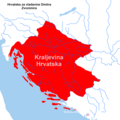
File:Hrvatska u vrijeme Zvonimira..png
Appearance

Size of this preview: 600 × 600 pixels. Other resolutions: 240 × 240 pixels | 480 × 480 pixels | 768 × 768 pixels | 1,024 × 1,024 pixels | 2,000 × 2,000 pixels.
Original file (2,000 × 2,000 pixels, file size: 121 KB, MIME type: image/png)
File history
Click on a date/time to view the file as it appeared at that time.
| Date/Time | Thumbnail | Dimensions | User | Comment | |
|---|---|---|---|---|---|
| current | 13:39, 3 February 2024 |  | 2,000 × 2,000 (121 KB) | Argo Navis | Reverted to version as of 20:30, 15 January 2022 (UTC), prema izvoru https://www.vrilo-mudrosti.hr/karte/vm-karta-kralj%20Petar%20KresimirIV.jpg |
| 22:31, 15 January 2022 |  | 2,000 × 2,000 (121 KB) | Ceha | Gornja Neretva i Podrinje, boja Dubrovnika i Kotora | |
| 20:34, 15 January 2022 |  | 2,000 × 2,000 (121 KB) | Ceha | Sjeverna granica je bila kod Ptuja | |
| 20:30, 15 January 2022 |  | 2,000 × 2,000 (121 KB) | Ceha | https://www.vrilo-mudrosti.hr/karte/vm-karta-kralj%20Petar%20KresimirIV.jpg Nije postojala Neretvanska kneževina, granice prema sjeverozapadu i istoku su bile drugačije | |
| 16:43, 4 January 2022 |  | 2,000 × 2,000 (206 KB) | Luigimini | Cross-wiki upload from hr.wikipedia.org |
File usage
The following 2 pages use this file:
Global file usage
The following other wikis use this file:
- Usage on de.wikipedia.org
- Usage on hr.wikipedia.org
- Usage on ja.wikipedia.org
