Jump to content

File:Houston Galveston area towns roadmap.gif

Page contents not supported in other languages.
This is a file from the Wikimedia Commons
From Wikipedia, the free encyclopedia

Houston_Galveston_area_towns_roadmap.gif (399 × 342 pixels, file size: 35 KB, MIME type: image/gif)

Summary

Description

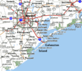
Map of Houston-Galveston area of Texas in the United States, showing:

Date
Source

Derived from image on US Goverment website: http://gulfsci.usgs.gov/galveston/images/map1lg.gif

Added "Brazoria N.W.S." and towns from Texas roadmap.
Author US Coast Guard

Licensing

Public domain
This image or file is a work of a United States Coast Guard service personnel or employee, taken or made as part of that person's official duties. As a work of the U.S. federal government, the image or file is in the public domain (17 U.S.C. § 101 and § 105, USCG main privacy policy and specific privacy policy for its imagery server).

العربية  English  italiano  日本語  македонски  മലയാളം  русский  sicilianu  Türkçe  українська  Tiếng Việt  +/−

Captions

Add a one-line explanation of what this file represents

Items portrayed in this file

depicts

13 September 2008

File history

Click on a date/time to view the file as it appeared at that time.

Date/TimeThumbnailDimensionsUserComment
current11:56, 24 September 2008Thumbnail for version as of 11:56, 24 September 2008399 × 342 (35 KB)Wikid77+Baytown, +Winnie, Brazoria_N.W.R.
17:59, 20 September 2008Thumbnail for version as of 17:59, 20 September 2008399 × 342 (35 KB)Wikid77added Port Bolivar, High Island, Sabine Pass; shifted "Galveston Island" darker "Houston"
07:18, 13 September 2008Thumbnail for version as of 07:18, 13 September 2008399 × 342 (34 KB)Wikid77initial upload

Global file usage

The following other wikis use this file: