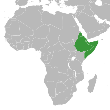
File:Horn of Africa states.svg
Appearance

Size of this PNG preview of this SVG file: 380 × 380 pixels. Other resolutions: 240 × 240 pixels | 480 × 480 pixels | 768 × 768 pixels | 1,024 × 1,024 pixels | 2,048 × 2,048 pixels.
Original file (SVG file, nominally 380 × 380 pixels, file size: 175 KB)
File history
Click on a date/time to view the file as it appeared at that time.
| Date/Time | Thumbnail | Dimensions | User | Comment | |
|---|---|---|---|---|---|
| current | 19:57, 12 July 2024 |  | 380 × 380 (175 KB) | Daljir | Reverted to version as of 09:13, 11 April 2024 (UTC) |
| 08:17, 22 May 2024 |  | 380 × 380 (174 KB) | Abo Yemen | Reverted to version as of 19:24, 29 October 2022 (UTC) | |
| 09:13, 11 April 2024 |  | 380 × 380 (175 KB) | Anwar8989 | Reverted to version as of 18:28, 9 September 2022 (UTC) | |
| 19:24, 29 October 2022 |  | 380 × 380 (174 KB) | Jacob300 | Reverted to version as of 19:03, 13 October 2021 (UTC) | |
| 18:28, 9 September 2022 |  | 380 × 380 (175 KB) | Anwar8989 | Reverted to version as of 22:08, 11 May 2015 (UTC) | |
| 19:03, 13 October 2021 |  | 380 × 380 (174 KB) | Gebagebo | Added Somaliland | |
| 22:08, 11 May 2015 |  | 380 × 380 (175 KB) | Master Uegly | new map with surroundings | |
| 13:35, 11 May 2015 |  | 1,000 × 1,000 (184 KB) | Master Uegly | {{Information |Description={{en|Map of Africa with states at the horn of Africa highlighted in green.}} {{de|Karte Afrikas, die Staaaten am Horn von Afrika grün hervorgehoben.}} {{ValidSVG}} |Source=derived from {{f|BlankMap-Africa.svg}} |Date=2015-05... |
File usage
The following 2 pages use this file:
Global file usage
The following other wikis use this file:
- Usage on af.wikipedia.org
- Usage on ar.wikipedia.org
- Usage on ast.wikipedia.org
- Usage on ca.wikipedia.org
- Usage on de.wikipedia.org
- Usage on eu.wikipedia.org
- Usage on fa.wikipedia.org
- Usage on fi.wikipedia.org
- Usage on frr.wikipedia.org
- Usage on ga.wikipedia.org
- Usage on gl.wikipedia.org
- Usage on ja.wikipedia.org
- Usage on kab.wikipedia.org
- Usage on ku.wikipedia.org
- Usage on no.wikipedia.org
- Usage on ro.wikipedia.org
- Usage on ru.wikipedia.org
- Usage on uk.wikipedia.org
- Usage on vec.wikipedia.org
- Usage on www.wikidata.org
- Usage on zh.wikipedia.org
