Jump to content

File:Hooker Map of the State of Coahuila and Texas 1834 UTA.jpg

Page contents not supported in other languages.
This is a file from the Wikimedia Commons
From Wikipedia, the free encyclopedia

Original file (2,456 × 2,058 pixels, file size: 3.77 MB, MIME type: image/jpeg)

Summary

Title
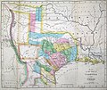
English: Map of the State of Coahuila and Texas
Description
English: Philadelphia engraver, printer, map publisher, and instrument maker William Hooker's Map of Coahuila and Texas first appeared in an 1833 promotional book on Texas by Mary Austin Holley (1784-1846), a first cousin of the famous Texas colonizer Stephen F. Austin. Holley and her publisher, Armstrong & Plaskitt of Baltimore substituted Hooker's map when Henry S. Tanner, the publisher of Stephen F. Austin's large map of Texas, refused to allow the latter to be used in the book. This later colored version Hooker's map appeared in an anonymous travel book on Texas sometime attributed to a certain "M. Fiske" of Mobile, Alabama. The author had sailed from New Orleans in March 1831 and had arrived in Brazoria (incorrectly spelled "Brazaria" on the map) to examine a large tract of land he had purchased from the Galveston Bay and Texas Land Company.
This 1834 map contains all the details of the earlier 1833 version but also refers to John McMullen and James McGloin's grant (contract awarded in 1828), James Power's grant (also awarded in 1828) — both in south Texas — as well as cryptic references to "J. Camerou" in North Texas (John Cameron, who was awarded a contract in 1827) and "De Leon" (Martin De Leon, awarded a contract in 1824). Other new details include "peaks in the west", "Presidio de Rio Grand" [sic], additional towns across the Rio Grande in Chihuahua and Coahuila, the Cross Timbers, "Tenoxticlan" (Fort Tenoxtitlan, constructed for the Mexican army in 1830), "Herds of Buffalo" and "Droves of Wild Cattle & Horses" (phrases copied directly from the Austin-Tanner map), Comanche Indian lands in the west, and Cherokee, Creek, and Choctaw Indian lands north of the Red River.
Date
Source UTA Libraries Cartographic Connections: map / text
Creator
William Hooker  (fl. 1804–1846)  wikidata:Q65922072
 
Description American geographer
Work period 1804 Edit this at Wikidata–1846 Edit this at Wikidata
Authority file
creator QS:P170,Q65922072
Credit line
English: The University of Texas at Arlington Libraries Special Collections, Gift of Jenkins Garrett
 Geotemporal data
Map location Mexico
Texas
Georeferencing Georeference the map in Wikimaps Warper If inappropriate please set warp_status = skip to hide.
 Bibliographic data
Publication
A Visit to Texas: Being the Journal of a Traveller Through Those Parts Most Interesting to American Settlers
Page(s) Frontispiece
Place of publication New York City
Publisher
Goodrich & Wiley
 Archival data
institution QS:P195,Q1230739
Dimensions height: 27 cm (10.6 in); width: 33 cm (12.9 in)
dimensions QS:P2048,27U174728
dimensions QS:P2049,33U174728
Medium colored engraving on paper
artwork-references

Huseman, Ben W. (2014) The Price of Manifest Destiny: Maps Relating to the Southwest Borderlands, 1800-1866, Arlington: The University of Texas at Arlington Libraries, p. 16

Huseman, Ben W. (2018) Paths to Highways: Routes of Exploration, Commerce, and Settlement, Arlington: The University of Texas at Arlington Libraries, no. 33 , p. 23

Streeter, Thomas W. (1983) Bibliography of Texas 1795-1845 (2nd ed.), Woodbridge: Research Publications, Inc., pp. 328, 376–377, 383, 397 "Revised and Enlarged by Archibald Hanna with a Guide to the Microfilm Collection. First published by Oxford University Press, 1955."

Davis, Marty, et al (2007) Going to Texas: Five Centuries of Texas Maps, Fort Worth: Texas Christian University Press, no. 17 , p. 35

Day, James M. (1964) Maps of Texas 1527-1900, Austin: The Pemberton Press, pp. 18, 22

"No. 188" in (2009) Dorothy Sloan Books Auction 22 catalog, Austin


Licensing

Public domain

The author died in 1846, so this work is in the public domain in its country of origin and other countries and areas where the copyright term is the author's life plus 100 years or fewer.


This work is in the public domain in the United States because it was published (or registered with the U.S. Copyright Office) before January 1, 1929.

This file has been identified as being free of known restrictions under copyright law, including all related and neighboring rights.

Captions

Add a one-line explanation of what this file represents

Items portrayed in this file

depicts

0.01666666666666666666 second

10.1875 millimetre

image/jpeg

File history

Click on a date/time to view the file as it appeared at that time.

Date/TimeThumbnailDimensionsUserComment
current20:28, 23 July 2019Thumbnail for version as of 20:28, 23 July 20192,456 × 2,058 (3.77 MB)Michael Barera== {{int:filedesc}} == {{Map |title = ''Map of the State of Coahuila and Texas'' |description = {{en|Philadelphia engraver, printer, map publisher, and instrument maker William Hooker's Map of Coahuila and Texas first appeared in an 1833 promotional book on Texas by Mary Austin Holley (1784-1846), a first cousin of the famous Texas colonizer Stephen F. Austin. Holley and her publisher, Armstrong & Plaskitt of Baltimore substituted Hooker's map when Henry S. Tanner, the pub...

The following page uses this file:

Global file usage

The following other wikis use this file:

Metadata