File:Hoja3 Plano FacundoCL.jpg

Original file (2,010 × 1,887 pixels, file size: 5.41 MB, MIME type: image/jpeg)
| This is a file from the Wikimedia Commons. Information from its description page there is shown below. Commons is a freely licensed media file repository. You can help. |
Summary
| DescriptionHoja3 Plano FacundoCL.jpg |
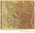
Español: Hoja 3 del Plano de Madrid en 1900, dibujado por Facundo Cañada.
Descripción física del plano total por el autor: "El plano consta de 6 hojas, cada una de las cuales mide 59 cm de altura por 72 cm de ancho (de trabajo, por supuesto, nada de anchos de cenefas), y, por lo tanto, al unirlas forman un plano que mide 1,44 metros de ancho y 1,77 de alto y las márgenes en blanco: se está tirando escrupulosamente en ocho colores y en superior papel, hallándose perfectamente grabado" (Facundo Cañada López, 1900). Descripción cartográfica del plato total: Plano de Madrid y Pueblos colindantes de Aravaca, Canillas, Canillejas, Carabanchel Alto, Carabanchel Bajo, Chamartín, El Pardo (Real Sitio), Fuencarral, Getafe, Hortaleza, Leganés, Pozuelo de Alarcón, con sus barrios de Húmera y Estación; Vallecas, Vicálvaro, Villaverde, etc, al principiar el siglo XX. El plano va acompañado de una Guía, con el Directorio de Madrid y otras notas aclaratorias. Información estadística y nomenclator del plano por el autor: La superficie del término municipal de Madrid de la época es de 821.189.581 pies cuadrados, equivalentes a 18.621 fanegas del marco de Madrid o sean 6475 hectáreas y 54 áreas; resultando de dicha superficie una proporción de 120,52 metros cuadrados por habitante, pues estos son 528.984, según el último empadronamiento general verificado en 1º de Diciembre de 1900. En el plano se fijan los nombres de las plazas, calles, callejones, cuestas, etc., que en la actualidad tienen, detallándose la numeración que a cada casa corresponde, dentro de cada manzana, pues se fijan los primeros y últimos números de cada una de éstas al principiar las calles, y después los últimos en las manzanas sucesivas, y de esta manera resulta toda la numeración de cada calle. |
||||||
| Date | |||||||
| Source | [1] | ||||||
| Author | Facundo Cañada | ||||||
| Permission (Reusing this file) |
|
||||||
| Other versions |
|
||||||
Licensing
| This file is made available under the Creative Commons CC0 1.0 Universal Public Domain Dedication. | |
| The person who associated a work with this deed has dedicated the work to the public domain by waiving all of their rights to the work worldwide under copyright law, including all related and neighboring rights, to the extent allowed by law. You can copy, modify, distribute and perform the work, even for commercial purposes, all without asking permission.
http://creativecommons.org/publicdomain/zero/1.0/deed.enCC0Creative Commons Zero, Public Domain Dedicationfalsefalse |
Licensing
|
This is a faithful photographic reproduction of a two-dimensional, public domain work of art. The work of art itself is in the public domain for the following reason:
The official position taken by the Wikimedia Foundation is that "faithful reproductions of two-dimensional public domain works of art are public domain".
This photographic reproduction is therefore also considered to be in the public domain in the United States. In other jurisdictions, re-use of this content may be restricted; see Reuse of PD-Art photographs for details. | |||||
Captions
Items portrayed in this file
depicts
1900
File history
Click on a date/time to view the file as it appeared at that time.
| Date/Time | Thumbnail | Dimensions | User | Comment | |
|---|---|---|---|---|---|
| current | 18:43, 15 December 2016 |  | 2,010 × 1,887 (5.41 MB) | Latemplanza | =={{int:filedesc}}== {{Information |description={{es|1=Hoja 3 del Plano de Madrid en 1900, dibujado por Facundo Cañada. Descripción física del plano total por el autor: "El plano consta de 6 hojas, cada una de las cuales mide 59 cm de altura por 72... |
File usage
The following page uses this file:
Global file usage
The following other wikis use this file:
- Usage on es.wikipedia.org
Metadata
This file contains additional information, probably added from the digital camera or scanner used to create or digitize it.
If the file has been modified from its original state, some details may not fully reflect the modified file.
| Width | 2,010 px |
|---|---|
| Height | 1,887 px |
| Bits per component |
|
| Pixel composition | RGB |
| Orientation | Normal |
| Number of components | 3 |
| Horizontal resolution | 300 dpi |
| Vertical resolution | 300 dpi |
| Software used | Adobe Photoshop CS5.1 Windows |
| File change date and time | 13:38, 21 October 2014 |
| Exif version | 2.21 |
| Color space | sRGB |
| Date metadata was last modified | 15:38, 21 October 2014 |
| Date and time of digitizing | 12:31, 6 July 2012 |
| Unique ID of original document | xmp.did:65ED2DBC3EC7E1119DADEBF8C6C8F1AE |
| IIM version | 162 |


