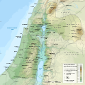
File:Herodian Kingdom topographic map.svg
Appearance

Size of this PNG preview of this SVG file: 600 × 600 pixels. Other resolutions: 240 × 240 pixels | 480 × 480 pixels | 768 × 768 pixels | 1,024 × 1,024 pixels | 2,048 × 2,048 pixels | 1,350 × 1,350 pixels.
Original file (SVG file, nominally 1,350 × 1,350 pixels, file size: 11.03 MB)
File history
Click on a date/time to view the file as it appeared at that time.
| Date/Time | Thumbnail | Dimensions | User | Comment | |
|---|---|---|---|---|---|
| current | 05:50, 1 January 2024 |  | 1,350 × 1,350 (11.03 MB) | DEGA MD | Administrative capital symbol optimization. Adraa, Gaulatinis and Sepphoris labels fixed. Gridline optimization. |
| 22:49, 26 December 2023 |  | 1,350 × 1,350 (11.03 MB) | DEGA MD | Borders shape optimization. Kedesh added. Emmaus label fixed. Alexandrium and Cyprus WGS 84 location fixed. | |
| 18:40, 21 December 2023 |  | 1,350 × 1,350 (11.13 MB) | DEGA MD | Regional borders added. Ginae label corrected. Ephemeral lakes opacity fixed. | |
| 03:49, 18 December 2023 |  | 1,350 × 1,350 (11.11 MB) | DEGA MD | External territory blend fix. Scale bar fix. | |
| 02:37, 18 December 2023 |  | 1,350 × 1,350 (11.28 MB) | DEGA MD | Uploaded own work with UploadWizard |
File usage
The following 3 pages use this file:
Global file usage
The following other wikis use this file:
- Usage on ms.wikipedia.org

