Jump to content

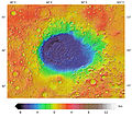
File:Hellas MOLA zoom 64 medium.jpg

Page contents not supported in other languages.
This is a file from the Wikimedia Commons
From Wikipedia, the free encyclopedia

Original file (7,600 × 7,000 pixels, file size: 20.87 MB, MIME type: image/jpeg)

Warning The original file is very high-resolution. It might not load properly or could cause your browser to freeze when opened at full size. Open in ZoomViewer

Summary

Description
English: A colorized topographic map of the martian impact basin Hellas, together with its surroundings, from the Mars Orbiter Laser Altimeter (MOLA) instrument of the Mars Global Surveyor spacecraft. Hellas, the deepest basin on Mars, lies in the southern hemisphere, south of Syrtis Major Planum.
Date
Source JMARS
Author NASA / JPL-Caltech / Arizona State University
Other versions

Licensing

Public domain This file is in the public domain in the United States because it was solely created by NASA. NASA copyright policy states that "NASA material is not protected by copyright unless noted". (See Template:PD-USGov, NASA copyright policy page or JPL Image Use Policy.)
Warnings:

Captions

Add a one-line explanation of what this file represents

Items portrayed in this file

depicts

30 November 2013

File history

Click on a date/time to view the file as it appeared at that time.

Date/TimeThumbnailDimensionsUserComment
current04:50, 1 December 2013Thumbnail for version as of 04:50, 1 December 20137,600 × 7,000 (20.87 MB)WolfmanSFUser created page with UploadWizard

The following page uses this file:

Global file usage

The following other wikis use this file:

Metadata