File:Hawaii Volcanoes Hazard Map.svg
Appearance

Size of this PNG preview of this SVG file: 310 × 335 pixels. Other resolutions: 222 × 240 pixels | 444 × 480 pixels | 711 × 768 pixels | 948 × 1,024 pixels | 1,895 × 2,048 pixels.
Original file (SVG file, nominally 310 × 335 pixels, file size: 174 KB)
File history
Click on a date/time to view the file as it appeared at that time.
| Date/Time | Thumbnail | Dimensions | User | Comment | |
|---|---|---|---|---|---|
| current | 19:13, 26 January 2013 |  | 310 × 335 (174 KB) | Resident Mario | Add a wee bit of spacing so that the image is not so cramped. |
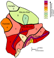
| 19:09, 26 January 2013 |  | 305 × 330 (174 KB) | Resident Mario | {{Information |Description ={{en|1=The Island of Hawaiʻi was mapped into 9 lava flow hazard zones meant to portray the future long-term hazard due to lava flow activity.}} |Source =Upconverted SVG based on [[:... |
File usage
The following 2 pages use this file:
Global file usage
The following other wikis use this file:
- Usage on ast.wikipedia.org
- Usage on ba.wikipedia.org
- Usage on ca.wikipedia.org
- Usage on es.wikipedia.org
- Usage on mk.wikipedia.org
- Usage on ru.wikipedia.org
- Usage on uk.wikipedia.org
