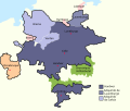
File:Hanover1720.png
Appearance

Size of this preview: 707 × 600 pixels. Other resolutions: 283 × 240 pixels | 566 × 480 pixels | 906 × 768 pixels | 1,208 × 1,024 pixels | 2,500 × 2,120 pixels.
Original file (2,500 × 2,120 pixels, file size: 537 KB, MIME type: image/png)
File history
Click on a date/time to view the file as it appeared at that time.
| Date/Time | Thumbnail | Dimensions | User | Comment | |
|---|---|---|---|---|---|
| current | 22:01, 24 November 2009 |  | 2,500 × 2,120 (537 KB) | The Illusional Ministry | Changed colours |
| 22:00, 24 November 2009 |  | 2,500 × 2,120 (537 KB) | The Illusional Ministry | Changed colours | |
| 07:56, 20 August 2007 |  | 2,500 × 2,120 (592 KB) | DrKay | {{Information |Description=Sketch map of the state of Hanover, c.1720 showing territorial acquisitions and some neighbouring states and imperial cities; drawn in Adobe Photoshop by hand using a pen tablet. |Source=self-made |Date= |Author= [[User:DrKierna |
File usage
The following 4 pages use this file:
Global file usage
The following other wikis use this file:
- Usage on ar.wikipedia.org
- Usage on be.wikipedia.org
- Usage on ckb.wikipedia.org
- Usage on cs.wikipedia.org
- Usage on da.wikipedia.org
- Usage on el.wikipedia.org
- Usage on es.wikipedia.org
- Usage on et.wikipedia.org
- Usage on fr.wikipedia.org
- Usage on he.wikipedia.org
- Usage on hu.wikipedia.org
- Usage on it.wikipedia.org
- Usage on ja.wikipedia.org
- Usage on la.wikipedia.org
- Usage on vi.wikipedia.org
- Usage on zh.wikipedia.org


