
File:Hamburg.Plan.1890.png
Size of this preview: 800 × 433 pixels. Other resolutions: 320 × 173 pixels | 640 × 346 pixels | 1,024 × 554 pixels | 1,280 × 692 pixels | 3,000 × 1,622 pixels.
Original file (3,000 × 1,622 pixels, file size: 2.39 MB, MIME type: image/png)
| This is a file from the Wikimedia Commons. Information from its description page there is shown below. Commons is a freely licensed media file repository. You can help. |
Summary
| Description |
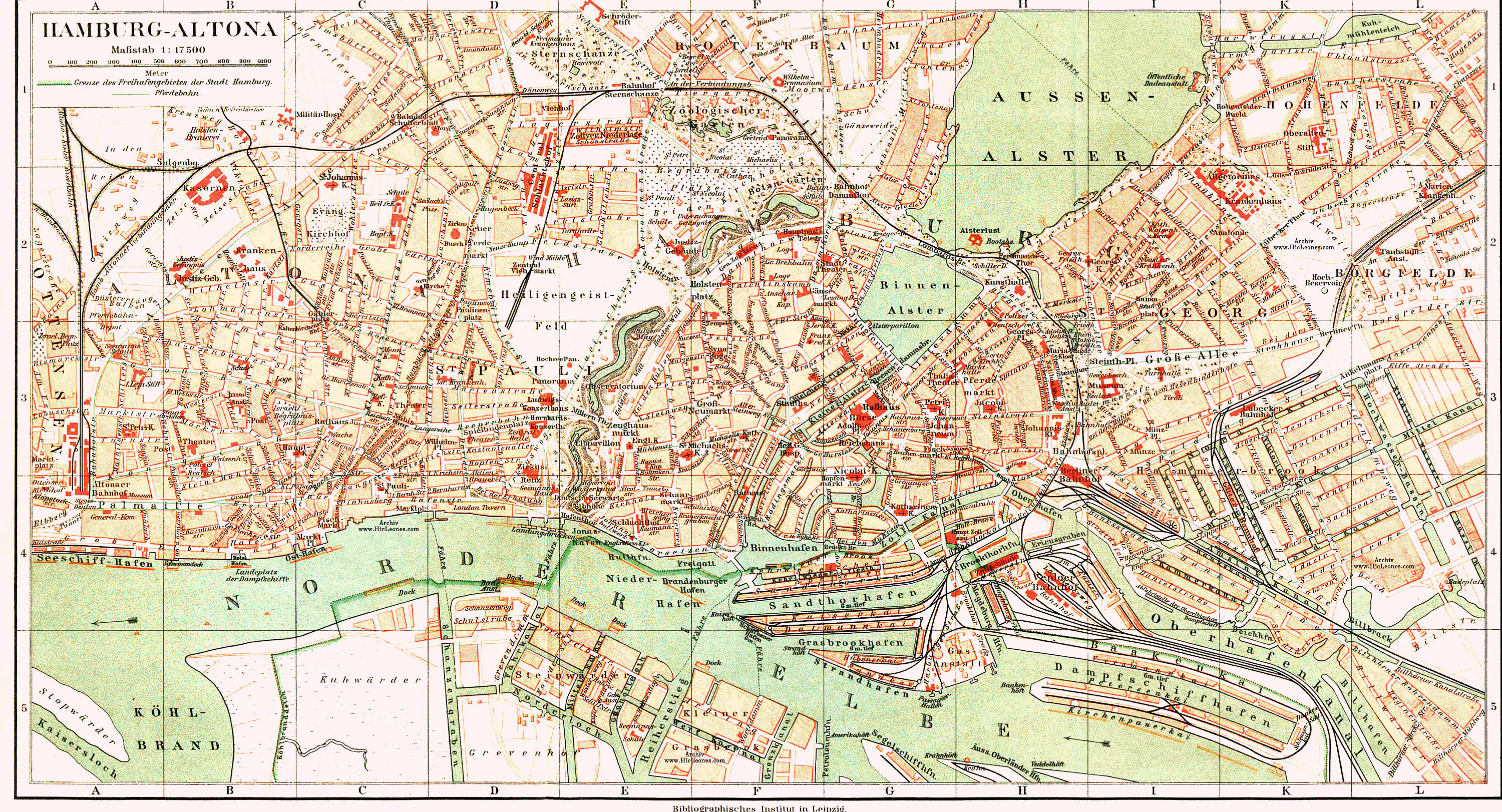
Deutsch: Plan von Hamburg und Altona ca. 1890
Das Hamburger Rathaus, erbaut 1886-1897, ist bereits eingezeichnet, nicht aber die 1893-1898 erfolgte Verlegung des Altonaer Bahnhofs an seinen heutigen Standort. Erst recht fehlen Mönckebergstraße und Hauptbahnhof, die erst nach 1900 errichtet wurden, und der Bereich um den Meßberg ist noch im alten Zustand. |
| Date | |
| Source | aus: Neumanns Orts-Lexikon des Deutschen Reich, Dritte, neu bearbeitete und vermehrte Auflage von W. Keil. Neuer Abdruck, Leipzig, Bibliografisches Institut, im Buch zwischen S. 306 und 307 |
| Author | Gustav Neumann, Wilhelm Keil |
| Other versions | c:File:441 of 'Neumanns Orts-Lexikon des Deutschen Reichs' (11229374685).jpg |
.jpg)
Licensing =
|
This work is in the public domain in its country of origin and other countries and areas where the copyright term is the author's life plus 70 years or fewer. | |
| This file has been identified as being free of known restrictions under copyright law, including all related and neighboring rights. | |
derivative works
Derivative works of this file:
- Altona Blutsonntag.png
- Altona-B.jpg
- Begraebnisplatz 1890..jpg
- Bf-altona-karte1890.jpg
- Geahlerplatz.png
- Grburstah.jpg
- Hamburg-Altona Palmaille1890.png
- Hamburg-Plan1890-Ausschnitt.jpg
- Hamburg.Plan.1890 Ausschnitt Hochhaus Trockendock markiert.png
- Hamburg.Plan.1890 Ausschnitt Hochhaus Trockendock.png
- Hamburg.Plan.1890 Ausschnitt Hochhaus.png
- Heiligengeistfeld.png
- Innenstadthh.png
- Karo1890.png
- Zollkanal.jpg
- Karte-holstenstraße-1890.png
File history
Click on a date/time to view the file as it appeared at that time.
| Date/Time | Thumbnail | Dimensions | User | Comment | |
|---|---|---|---|---|---|
| current | 18:35, 14 October 2005 | | 3,000 × 1,622 (2.39 MB) | Wmeinhart | Plan von Hamburg und Altona aus Ritters geographisch-statistischem Lexikon, Bd. A-K, 8. Aufl. (1895), Ed. J. Penzler, Otto Wiegand, Leipzig, Bibligrafisches Institut |
File usage
The following page uses this file:
Global file usage
The following other wikis use this file:
- Usage on de.wikipedia.org
- Bezirk Altona
- Franz Adickes (Politiker)
- Hamburger Wallanlagen
- Benutzer:Wmeinhart/foto
- Hamburg-Altonaer Verbindungsbahn
- Straßenbahn Hamburg
- Portal Diskussion:Hamburg/Archiv1
- Benutzer:Blauerflummi/Hamburg-Altonaer Verbindungsbahn
- Diskussion:Holstenstraße (Hamburg)
- Diskussion:Hamburg-Altonaer Verbindungsbahn/Archiv/1
- Wikipedia:Fotowerkstatt/Archiv/2016/April
- Altonaer Holzhafen
- Diskussion:Hamburg/Archiv/2006
- Usage on ja.wikipedia.org
- Usage on no.wikipedia.org
- Usage on sv.wikipedia.org
- Usage on www.wikidata.org