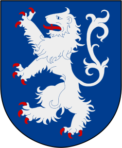
File:Halland vapen.svg
Appearance

Size of this PNG preview of this SVG file: 251 × 304 pixels. Other resolutions: 198 × 240 pixels | 396 × 480 pixels | 634 × 768 pixels | 845 × 1,024 pixels | 1,691 × 2,048 pixels.
Original file (SVG file, nominally 251 × 304 pixels, file size: 71 KB)
File history
Click on a date/time to view the file as it appeared at that time.
| Date/Time | Thumbnail | Dimensions | User | Comment | |
|---|---|---|---|---|---|
| current | 22:13, 14 August 2011 |  | 251 × 304 (71 KB) | L PBot | Updating colours per sv:Wikipediadiskussion:Projekt_heraldik#Färger. |
| 19:18, 28 October 2007 |  | 251 × 304 (71 KB) | Lokal Profil | {{Information |Description={{sv|Hallands länsvapen samt Hallands landskapsvapen.<br> Blasonering: ''I blått ett upprest lejon av silver med röd beväring, därest dylik skall komma till användning.''}} {{en|Coat o |
File usage
More than 100 pages use this file. The following list shows the first 100 pages that use this file only. A full list is available.
- Anneberg, Kungsbacka
- Backa, Kungsbacka
- Bergagård
- Billdal
- Brattås
- Bua, Varberg Municipality
- Buerås
- Counties of Sweden
- Eldsberga
- Fegen (locality)
- Fjärås kyrkby
- Forsbäck
- Frillesås
- Frösakull
- Fyllinge
- Genevad
- Getinge
- Glommen, Falkenberg Municipality
- Gullbrandstorp
- Gullbranna
- Gundal och Högås
- Hagryd-Dala
- Halla Heberg
- Halland County
- Harplinge
- Hasslöv
- Haverdal
- Heberg
- Himle (locality)
- Hishult
- Hjälm
- Hjälmared, Kungsbacka
- Holm, Halmstad
- Högvadsån
- Kläppa
- Knäred
- Kungsäter
- Kvibille
- Laxvik
- Lerkil
- Lilla Tjärby
- List of governors of Halland County
- List of political and geographic subdivisions by total area (all)
- List of political and geographic subdivisions by total area from 5,000 to 20,000 square kilometers
- List of political and geographic subdivisions by total area from 5,000 to 7,000 square kilometers
- Långås
- Löftaskog
- Mellbystrand
- Morup
- Okome
- Ringsegård
- Rolfstorp
- Ränneslöv
- Råö
- Röda holme
- Sennan, Halmstad
- Simlångsdalen
- Skedala
- Skogstorp, Falkenberg Municipality
- Skottorp
- Skrea
- Skreanäs
- Skummeslövsstrand
- Skällinge
- Skärbäck
- Skåneland
- Slöinge
- Steninge
- Sumpafallen
- Särö
- Södra Näs
- Tofta, Varberg Municipality
- Träslövsläge
- Trönninge, Halmstad
- Trönninge, Varberg Municipality
- Tvååker
- Tångaberg
- Vallberga
- Vallda
- Vassbäck
- Veddige
- Veinge
- Vessigebro
- Villshärad
- Vinbergs kyrkby
- Västra Hagen
- Våxtorp
- Ysby
- Älvsered
- Ätran (locality)
- Årnäs
- Årstad, Falkenberg Municipality
- Åsa, Kungsbacka
- Åsby
- Ölmanäs
- Övraby
- User:Extended Cut/sandbox
- User:Hosmich/Roundels
- User:JerkerES
- Template:COVID-19 pandemic data/Sweden medical cases
View more links to this file.
Global file usage
The following other wikis use this file:
- Usage on af.wikipedia.org
- Usage on an.wikipedia.org
- Usage on ar.wikipedia.org
- Usage on ast.wikipedia.org
- Usage on avk.wikipedia.org
- Usage on be-tarask.wikipedia.org
- Usage on be.wikipedia.org
- Usage on bg.wikipedia.org
- Usage on br.wikipedia.org
- Usage on ca.wikipedia.org
- Usage on ceb.wikipedia.org
- Usage on cs.wikipedia.org
- Usage on da.wikipedia.org
View more global usage of this file.


