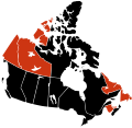
File:H1N1 Canada map.svg
Appearance

Size of this PNG preview of this SVG file: 617 × 599 pixels. Other resolutions: 247 × 240 pixels | 494 × 480 pixels | 791 × 768 pixels | 1,054 × 1,024 pixels | 2,108 × 2,048 pixels | 978 × 950 pixels.
Original file (SVG file, nominally 978 × 950 pixels, file size: 65 KB)
File history
Click on a date/time to view the file as it appeared at that time.
| Date/Time | Thumbnail | Dimensions | User | Comment | |
|---|---|---|---|---|---|
| current | 02:47, 8 December 2009 |  | 978 × 950 (65 KB) | Fonadier | First death in the Northwest Territories |
| 03:00, 24 November 2009 |  | 978 × 950 (65 KB) | Fonadier | Updated to November 23, 2009 | |
| 11:49, 4 November 2009 |  | 978 × 950 (70 KB) | Hariboneagle927 | first death in Labrador and Yukon | |
| 01:32, 8 October 2009 |  | 978 × 950 (65 KB) | Fonadier | Fixed map | |
| 00:14, 4 August 2009 |  | 978 × 950 (76 KB) | Fonadier | Deaths in Nova Scotia | |
| 23:58, 18 July 2009 |  | 978 × 950 (76 KB) | Fonadier | Updated map | |
| 06:11, 17 July 2009 |  | 978 × 950 (76 KB) | Vrysxy | updating | |
| 05:44, 15 July 2009 |  | 978 × 950 (76 KB) | Vrysxy | Updating | |
| 00:59, 10 July 2009 |  | 978 × 950 (76 KB) | Fonadier | Updated map | |
| 01:03, 9 July 2009 |  | 978 × 950 (76 KB) | Fonadier | {{Information |Description={{en|1=Map showing provinces and territories reporting 2009 swine flu (H1N1) cases in Canada. <br /> {{legend|#000000|Confirmed death and infe |
File usage
The following 4 pages use this file:
Global file usage
The following other wikis use this file:
- Usage on fr.wikipedia.org
- Usage on nl.wikipedia.org
- Usage on pl.wikipedia.org
- Usage on vi.wikipedia.org
- Usage on zh.wikipedia.org


