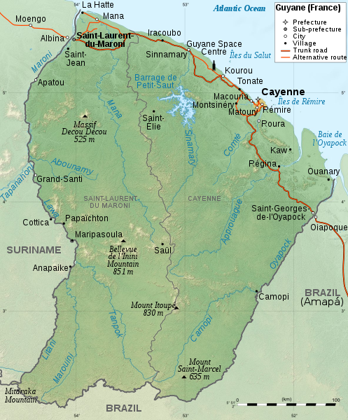
File:Guyane map-en.svg
Appearance

Size of this PNG preview of this SVG file: 497 × 600 pixels. Other resolutions: 199 × 240 pixels | 398 × 480 pixels | 637 × 768 pixels | 849 × 1,024 pixels | 1,698 × 2,048 pixels | 1,183 × 1,427 pixels.
Original file (SVG file, nominally 1,183 × 1,427 pixels, file size: 894 KB)
File history
Click on a date/time to view the file as it appeared at that time.
| Date/Time | Thumbnail | Dimensions | User | Comment | |
|---|---|---|---|---|---|
| current | 16:57, 3 April 2009 |  | 1,183 × 1,427 (894 KB) | RaviC | minor correction |
| 16:45, 3 April 2009 |  | 1,183 × 1,427 (907 KB) | RaviC | uploaded correct file | |
| 16:35, 3 April 2009 |  | 1,183 × 1,427 (907 KB) | RaviC | == Description == {{Information |Description={{en|1=Map of French Guiana.}} {{fr|1=Carte de la Guyane.}} |Source=travail personnel (own work). Sources : * File:Guyane department relief location map.jpg by {{u|Stin |
File usage
The following 6 pages use this file:
Global file usage
The following other wikis use this file:
- Usage on als.wikipedia.org
- Usage on el.wikipedia.org
- Usage on en.wikibooks.org
- Usage on eo.wikipedia.org
- Usage on fi.wikipedia.org
- Usage on fo.wikipedia.org
- Usage on hy.wikipedia.org
- Usage on it.wikipedia.org
- Usage on ja.wikipedia.org
- Usage on ka.wikipedia.org
- Usage on kk.wikipedia.org
- Usage on kn.wikipedia.org
- Usage on ko.wikipedia.org
- Usage on nl.wikipedia.org
- Usage on pl.wikipedia.org
- Usage on pl.wiktionary.org
- Usage on pms.wikipedia.org
- Usage on pt.wikipedia.org
- Usage on ro.wikipedia.org
- Usage on se.wikipedia.org
- Usage on simple.wikipedia.org
- Usage on sk.wikipedia.org
- Usage on su.wikipedia.org
- Usage on sv.wikipedia.org
- Usage on tt.wikipedia.org
- Usage on uk.wikipedia.org
- Usage on vi.wikipedia.org


