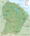
File:Guyane department relief location map.jpg
Appearance

Size of this preview: 497 × 600 pixels. Other resolutions: 199 × 240 pixels | 398 × 480 pixels | 637 × 768 pixels | 1,183 × 1,427 pixels.
Original file (1,183 × 1,427 pixels, file size: 439 KB, MIME type: image/jpeg)
File history
Click on a date/time to view the file as it appeared at that time.
| Date/Time | Thumbnail | Dimensions | User | Comment | |
|---|---|---|---|---|---|
| current | 13:55, 18 July 2010 |  | 1,183 × 1,427 (439 KB) | Sting | Color profile |
| 00:14, 19 September 2008 |  | 1,183 × 1,427 (441 KB) | Sting | == Summary == {{Location|03|55|30|N|53|06|00|W|scale:4000000}} <br/> {{Information |Description={{en|Blank physical map of the region and department of the French Guiana, France, for geo-location purpose, with distinct boundaries for |
File usage
The following 30 pages use this file:
- Approuague
- Bellevue de l'Inini
- Cottica Mountain
- Counamama
- Fort Cépérou
- Grand Abounami
- Guiana Amazonian Park
- Inini (river)
- Kaw Mountain
- Kourou (river)
- Koursibo
- Lawa River (South America)
- Mahury
- Malani (river)
- Mont Itoupé
- Petit-Saut Dam
- Rivière de Cayenne
- Tampok
- Voltaire Falls
- Waki (river)
- Yaloupi
- Talk:French Guiana
- User:LeheckaG
- User:Michael!/Project:Location map templates/France
- Wikipedia:Userboxes/Location/French Guiana
- Wikipedia:WikiProject South America/French Guiana work group
- Template:User French Guiana work group
- Category:French Guiana work group participants
- Module:Location map/data/French Guiana
- Module:Location map/data/French Guiana/doc
Global file usage
The following other wikis use this file:
- Usage on als.wikipedia.org
- Usage on ar.wikipedia.org
- Usage on ast.wikipedia.org
- Usage on ban.wikipedia.org
- Usage on be-tarask.wikipedia.org
- Usage on bg.wikipedia.org
- Usage on bs.wikipedia.org
- Usage on ceb.wikipedia.org
- Usage on ce.wikipedia.org
- Usage on ckb.wikipedia.org
- Usage on cs.wikipedia.org
- Usage on da.wikipedia.org
- Usage on de.wikipedia.org
- Europäische Weltraumorganisation
- Teufelsinsel (Französisch-Guayana)
- Îles du Salut
- Vorlage:Positionskarte Französisch-Guayana
- Wikipedia:Kartenwerkstatt/Positionskarten/Südamerika
- Benutzer Diskussion:Alexrk2/Archiv
- Bellevue de l’Inini
- Île Royale
- Île Saint-Joseph
- Petit-Saut-Staudamm
- Vorlage Diskussion:Karte in einer Ecke
- Usage on de.wikivoyage.org
- Usage on el.wikipedia.org
- Usage on eo.wikipedia.org
- Usage on es.wikipedia.org
- Usage on et.wikipedia.org
- Usage on fa.wikipedia.org
View more global usage of this file.


