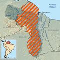
File:Guayana Esequiba (zona completa).png
Appearance

Size of this preview: 598 × 600 pixels. Other resolutions: 239 × 240 pixels | 479 × 480 pixels | 784 × 786 pixels.
Original file (784 × 786 pixels, file size: 830 KB, MIME type: image/png)
File history
Click on a date/time to view the file as it appeared at that time.
| Date/Time | Thumbnail | Dimensions | User | Comment | |
|---|---|---|---|---|---|
| current | 00:54, 4 June 2023 |  | 784 × 786 (830 KB) | Usedbook | Reverting to Lojwe (12 Oct 2021) due to possible vandalism. Borders of Guyana were manipulated, erased, and distorted. See miniature map and also border with Suriname. |
| 22:54, 23 January 2023 |  | 784 × 786 (844 KB) | SurinameCentral | Suriname boundary | |
| 18:02, 12 October 2021 |  | 784 × 786 (830 KB) | Lojwe | Cropped 2 % horizontally, 2 % vertically using CropTool with precise mode. | |
| 09:24, 15 August 2016 |  | 800 × 800 (836 KB) | Kordas | Naranja más oscurecido | |
| 22:21, 2 July 2016 |  | 800 × 800 (835 KB) | Kordas | == {{int:filedesc}} == {{Information |Description={{es|Mapa de la Guayana Esequiba; la zona rayada en naranja constituye el área reclamada por Venezuela.}} |Source=*Guayana Esequiba (zonas).png |Date=2010-12-23 1... |
File usage
The following 5 pages use this file:
Global file usage
The following other wikis use this file:
- Usage on be.wikipedia.org
- Usage on bs.wikipedia.org
- Usage on da.wikipedia.org
- Usage on de.wikinews.org
- Usage on es.wikipedia.org
- Usage on fa.wikipedia.org
- Usage on fi.wikipedia.org
- Usage on fr.wikipedia.org
- Usage on fr.wiktionary.org
- Usage on he.wikipedia.org
- Usage on hy.wikipedia.org
- Usage on id.wikipedia.org
- Usage on lv.wikipedia.org
- Usage on pl.wikipedia.org
- Usage on pt.wikipedia.org
- Usage on pt.wikinews.org
- Usage on ro.wikipedia.org
- Usage on ru.wikipedia.org
- Usage on sv.wikipedia.org
- Usage on th.wikipedia.org
- Usage on tr.wikipedia.org
View more global usage of this file.
