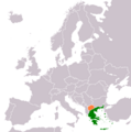
File:Greece North Macedonia Locator.png
Appearance

Size of this preview: 595 × 599 pixels. Other resolutions: 238 × 240 pixels | 477 × 480 pixels | 762 × 768 pixels | 1,236 × 1,245 pixels.
Original file (1,236 × 1,245 pixels, file size: 59 KB, MIME type: image/png)
File history
Click on a date/time to view the file as it appeared at that time.
| Date/Time | Thumbnail | Dimensions | User | Comment | |
|---|---|---|---|---|---|
| current | 15:11, 15 March 2015 |  | 1,236 × 1,245 (59 KB) | Gre regiment | Better map |
| 14:24, 15 March 2015 |  | 1,357 × 628 (36 KB) | Gre regiment | Some more fixes on the map | |
| 14:13, 15 March 2015 |  | 1,357 × 628 (36 KB) | Gre regiment | I had forgot to fill with green color the Crete | |
| 14:02, 15 March 2015 |  | 1,357 × 628 (36 KB) | Gre regiment | {{subst:Upload marker added by en.wp UW}} {{Information |Description = {{en|Map indicating location of Greece and Republic of Macedonia}} |Source = {{own}} |Date = 2015/3/15 |Author = Gre regiment }} |
File usage
The following 3 pages use this file:
Global file usage
The following other wikis use this file:
- Usage on el.wikipedia.org
- Usage on es.wikipedia.org
- Usage on fa.wikipedia.org
- Usage on he.wikipedia.org
- Usage on id.wikipedia.org
- Usage on it.wikipedia.org
- Usage on pt.wikipedia.org
- Usage on ru.wikipedia.org
- Usage on sr.wikipedia.org
- Usage on tr.wikipedia.org
- Usage on www.wikidata.org
- Usage on zh.wikipedia.org

