
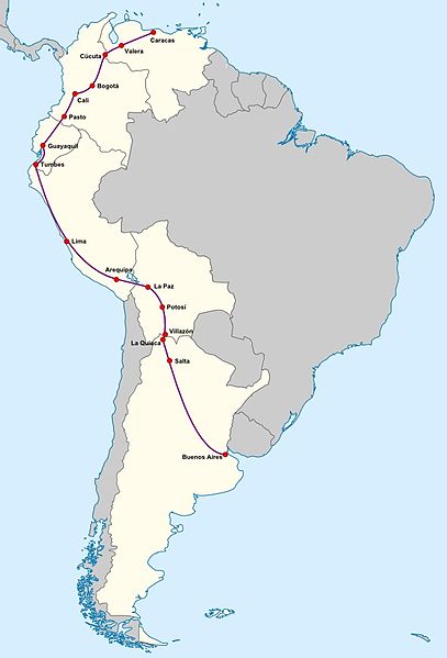
File:Gran Premio de la America del Sur del TC.jpg

Size of this preview: 407 × 599 pixels. Other resolutions: 163 × 240 pixels | 326 × 480 pixels | 643 × 947 pixels.
Original file (643 × 947 pixels, file size: 66 KB, MIME type: image/jpeg)
| This is a file from the Wikimedia Commons. Information from its description page there is shown below. Commons is a freely licensed media file repository. You can help. |
Summary
| Description |
English: Location map of SouthAmerica. * Projection: Lambert azimuthal equal-area projection. * Area of interest: :* N: 25.0° N :* S: -60.0° N :* W: -90.0° E :* E: -30.0° E * Projection center: :* NS: -17.5° N :* WE: -60.0° E * GMT projection: -JA-60/-17.5/20.0c * GMT region: -R-111.71735564517205/-55.20793284837989/-29.863824948966922/25.8980715779886r * GMT region for grdcut: -R-112.0/-63.0/-8.0/26.0r * Made with Natural Earth. Free vector and raster map data @ naturalearthdata.com. |
| Date | (UTC) |
| Source |
This file was derived from: World location map (equirectangular 180).svg: |
| Author |
|
.svg)
| This is a retouched picture, which means that it has been digitally altered from its original version. Modifications: Trazado del recorrido del Gran Premio de la América del Sur del TC. The original can be viewed here: World location map (equirectangular 180).svg:
|
Licensing
I, the copyright holder of this work, hereby publish it under the following licenses:
This file is licensed under the Creative Commons Attribution-Share Alike 3.0 Unported license.
- You are free:
- to share – to copy, distribute and transmit the work
- to remix – to adapt the work
- Under the following conditions:
- attribution – You must give appropriate credit, provide a link to the license, and indicate if changes were made. You may do so in any reasonable manner, but not in any way that suggests the licensor endorses you or your use.
- share alike – If you remix, transform, or build upon the material, you must distribute your contributions under the same or compatible license as the original.

|
Permission is granted to copy, distribute and/or modify this document under the terms of the GNU Free Documentation License, Version 1.2 or any later version published by the Free Software Foundation; with no Invariant Sections, no Front-Cover Texts, and no Back-Cover Texts. A copy of the license is included in the section entitled GNU Free Documentation License. |
You may select the license of your choice.
Original upload log
This image is a derivative work of the following images:
- File:World location map (equirectangular 180).svg licensed with Cc-by-sa-3.0, GFDL
Uploaded with derivativeFX
File history
Click on a date/time to view the file as it appeared at that time.
| Date/Time | Thumbnail | Dimensions | User | Comment | |
|---|---|---|---|---|---|
| current | 09:06, 27 July 2012 | | 643 × 947 (66 KB) | Milenioscuro | mejora del mapa |
| 00:47, 26 July 2012 |  | 532 × 800 (90 KB) | Diego HC | == {{int:filedesc}} == {{Information |Description={{en|1= Location map of SouthAmerica. * Projection: Lambert azimuthal equal-area projection. * Area of interest: :* N: 25.0° N :* S: -60.0° N :* W: -90.0° E :* E: -30.0° E * Projection center: :* NS... |
File usage
The following page uses this file:
Global file usage
The following other wikis use this file:
- Usage on es.wikipedia.org