Jump to content

File:Gran Colombia in 1826.svg

Page contents not supported in other languages.
This is a file from the Wikimedia Commons
From Wikipedia, the free encyclopedia

Original file (SVG file, nominally 2,966 × 2,508 pixels, file size: 7.58 MB)

Summary

Description
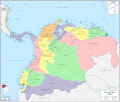
español (es): Mapa político de la Gran Colombia (1826).

Mapa histórico de la Gran Colombia, denotando sus límites y su división administrativa.

El presente mapa comprende la división político administrativa de la Gran Colombia en 1826, época en la cual el país estaba dividido en 13 departamentos, y estos en provincias, según lo dispuesto en la ley 18 de abril de 1826, adicional a la del 25 de junio de 1824:

  • Apure
  • Azuay
  • Boyacá
  • Cauca
  • Cundinamarca
  • Ecuador
  • Guayaquil
  • Istmo
  • Magdalena
  • Maturín
  • Orinoco
  • Venezuela
  • Zulia

En este mapa se muestran las capitales de éstas entidades en el momento de su creación. Los cantones son los que tenía el país en 1825, según el censo realizado en dicho año.

Las fronteras nacionales y subnacionales están trazadas en base a los mapas de José Manuel Restrepo, quien en 1827 dibujó el primer (y único) atlas nacional de la Gran Colombia. De igual manera sirvieron de referencias los mapas de la Gran Colombia de Agustín Codazzi publicado en 1840 y el de Manuel María Paz publicado en 1890. También se usaron algunos mapas coloniales de los siglos XVIII y XIX, particularmente para el istmo de Panamá.

Date
Source

Own work

Carta plana de la provincia de La Hacha (Don Juan López, 1786)
Carta marítima del Reyno de Tierra o Castilla del Oro (Don Juan López, 1785)
Author Milenioscuro
Permission
(Reusing this file)

Trabajo propio, reconocimiento requerido, mantener licencia: (Creative Commons CC-BY-SA-3.0). Citar a Wikipedia ó a Wikimedia como fuente si la imagen es utilizada en otros medios que no sean de los proyectos de la familia Wikipedia.

I, the copyright holder of this work, hereby publish it under the following license:
w:en:Creative Commons
attribution share alike
This file is licensed under the Creative Commons Attribution-Share Alike 3.0 Unported license.
You are free:
  • to share – to copy, distribute and transmit the work
  • to remix – to adapt the work
Under the following conditions:
  • attribution – You must give appropriate credit, provide a link to the license, and indicate if changes were made. You may do so in any reasonable manner, but not in any way that suggests the licensor endorses you or your use.
  • share alike – If you remix, transform, or build upon the material, you must distribute your contributions under the same or compatible license as the original.
SVG development
InfoField
 
The source code of this SVG is invalid due to 8 errors.
 
This W3C-invalid map was created with Adobe Illustrator,
 
and with Inkscape.

Licensing

I, the copyright holder of this work, hereby publish it under the following license:
w:en:Creative Commons
attribution share alike
This file is licensed under the Creative Commons Attribution-Share Alike 4.0 International license.
You are free:
  • to share – to copy, distribute and transmit the work
  • to remix – to adapt the work
Under the following conditions:
  • attribution – You must give appropriate credit, provide a link to the license, and indicate if changes were made. You may do so in any reasonable manner, but not in any way that suggests the licensor endorses you or your use.
  • share alike – If you remix, transform, or build upon the material, you must distribute your contributions under the same or compatible license as the original.

Captions

Add a one-line explanation of what this file represents

Items portrayed in this file

depicts

25 February 2018

image/svg+xml

7,945,014 byte

2,508 pixel

2,966 pixel

04bd416336ab064383a5543f85b677ef79619c74

File history

Click on a date/time to view the file as it appeared at that time.

Date/TimeThumbnailDimensionsUserComment
current16:45, 14 August 2022Thumbnail for version as of 16:45, 14 August 20222,966 × 2,508 (7.58 MB)Milenioscurocorregido el esequibo
20:29, 25 February 2018Thumbnail for version as of 20:29, 25 February 20182,966 × 2,508 (2.95 MB)MilenioscuroUser created page with UploadWizard

The following page uses this file:

Global file usage

Metadata