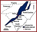
File:GoldMines-CarolinaSlateBelt.jpg
Appearance
GoldMines-CarolinaSlateBelt.jpg (300 × 257 pixels, file size: 20 KB, MIME type: image/jpeg)
File history
Click on a date/time to view the file as it appeared at that time.
| Date/Time | Thumbnail | Dimensions | User | Comment | |
|---|---|---|---|---|---|
| current | 17:29, 28 February 2010 |  | 300 × 257 (20 KB) | Plazak | {{Information |Description = Map of gold mines in the Carolina Slate Belt, USA |Source = US Geological Survey website: http://pubs.usgs.gov/info/ayuso1/ |Date = ~~~~~ |Author = USGS |Permission = US federal government |
File usage
The following 2 pages use this file:


