File:GlossopMap.svg
Appearance

Size of this PNG preview of this SVG file: 549 × 599 pixels. Other resolutions: 220 × 240 pixels | 440 × 480 pixels | 704 × 768 pixels | 938 × 1,024 pixels | 1,877 × 2,048 pixels | 702 × 766 pixels.
Original file (SVG file, nominally 702 × 766 pixels, file size: 581 KB)
File history
Click on a date/time to view the file as it appeared at that time.
| Date/Time | Thumbnail | Dimensions | User | Comment | |
|---|---|---|---|---|---|
| current | 18:13, 7 July 2008 |  | 702 × 766 (581 KB) | ClemRutter | Repairing: text to path bug |
| 18:04, 7 July 2008 |  | 702 × 766 (563 KB) | ClemRutter | Repairing: text to path bug | |
| 17:49, 7 July 2008 |  | 702 × 766 (565 KB) | ClemRutter | Repairing: text to path bug | |
| 17:44, 7 July 2008 |  | 702 × 766 (565 KB) | ClemRutter | Repairing: text to path bug | |
| 17:29, 7 July 2008 |  | 702 × 766 (529 KB) | ClemRutter | Repairing: text to path bug | |
| 17:24, 7 July 2008 |  | 702 × 766 (539 KB) | ClemRutter | Repairing: text to path bug | |
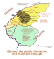
| 14:18, 6 July 2008 |  | 702 × 766 (129 KB) | ClemRutter | A map of {{w|Glossop|Glossop}} in Derbyshire, showing how the name has been attached to differing areas in the last 900 years. The original hamlet or township is now called Old Glossop, and Howard Town is now called Glossop. The manor occupied half area o | |
| 14:15, 6 July 2008 |  | 702 × 766 (133 KB) | ClemRutter | {{Information |Description={{en|1=A map of {{w|Glossop|Glossop}} in Derbyshire, showing how the name has been attached to differing areas in the last 900 years. The original hamlet or township is now called Old Glossop, and Howard Town is now called Gloss |
File usage
The following page uses this file:
Global file usage
The following other wikis use this file:
- Usage on azb.wikipedia.org

