File:Glasgow Subway map.png
Appearance

Size of this preview: 800 × 475 pixels. Other resolutions: 320 × 190 pixels | 640 × 380 pixels | 1,213 × 720 pixels.
Original file (1,213 × 720 pixels, file size: 33 KB, MIME type: image/png)
Summary
[edit] | Do not copy this file to Wikimedia Commons. This file is free content in the United States but non-free or potentially non-free in its country of origin. Wikimedia Commons only accepts files that are public domain or freely licensed in both the country of origin and the United States. For more details, see Wikipedia:Copyrights and talk for the PD-US license template. |
| Description |
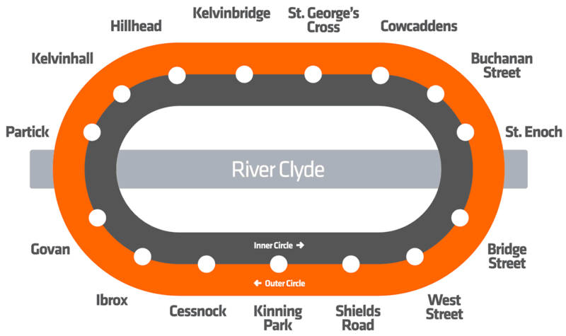
This is a simple map of the current stations of the Glasgow Subway, depicting both lines of the Subway and the River Clyde |
|---|---|
| Source | |
| Date | |
| Author |
SPT |
| Permission (Reusing this file) |
See below.
|
- Other information
This simply depicts the map of the Glasgow Subway using simple shapes and a few place names.
Licensing
[edit]| This image only consists of typefaces, individual words, slogans, or simple geometric shapes. These are not eligible for copyright alone because they are not original enough, and thus the image is considered to be in the public domain. For more information, see Wikipedia:Public domain – Fonts. Please note that there may be non-copyright restrictions protecting this image, such as trademarks and design patents. |
File history
Click on a date/time to view the file as it appeared at that time.
| Date/Time | Thumbnail | Dimensions | User | Comment | |
|---|---|---|---|---|---|
| current | 18:59, 11 October 2016 |  | 1,213 × 720 (33 KB) | Eosaph (talk | contribs) | Uploading a public-domain item using File Upload Wizard |
You cannot overwrite this file.
File usage
The following 4 pages use this file:
