
File:Gibraltar East Side Water Catchments in 1992.jpg
Size of this preview: 800 × 529 pixels. Other resolutions: 320 × 212 pixels | 640 × 423 pixels | 1,024 × 677 pixels | 1,173 × 776 pixels.
Original file (1,173 × 776 pixels, file size: 208 KB, MIME type: image/jpeg)
| This is a file from the Wikimedia Commons. Information from its description page there is shown below. Commons is a freely licensed media file repository. You can help. |
| This image appeared on Wikipedia's Main Page in the Did you know? column on 30 September 2013 (see archives). |
| Description |
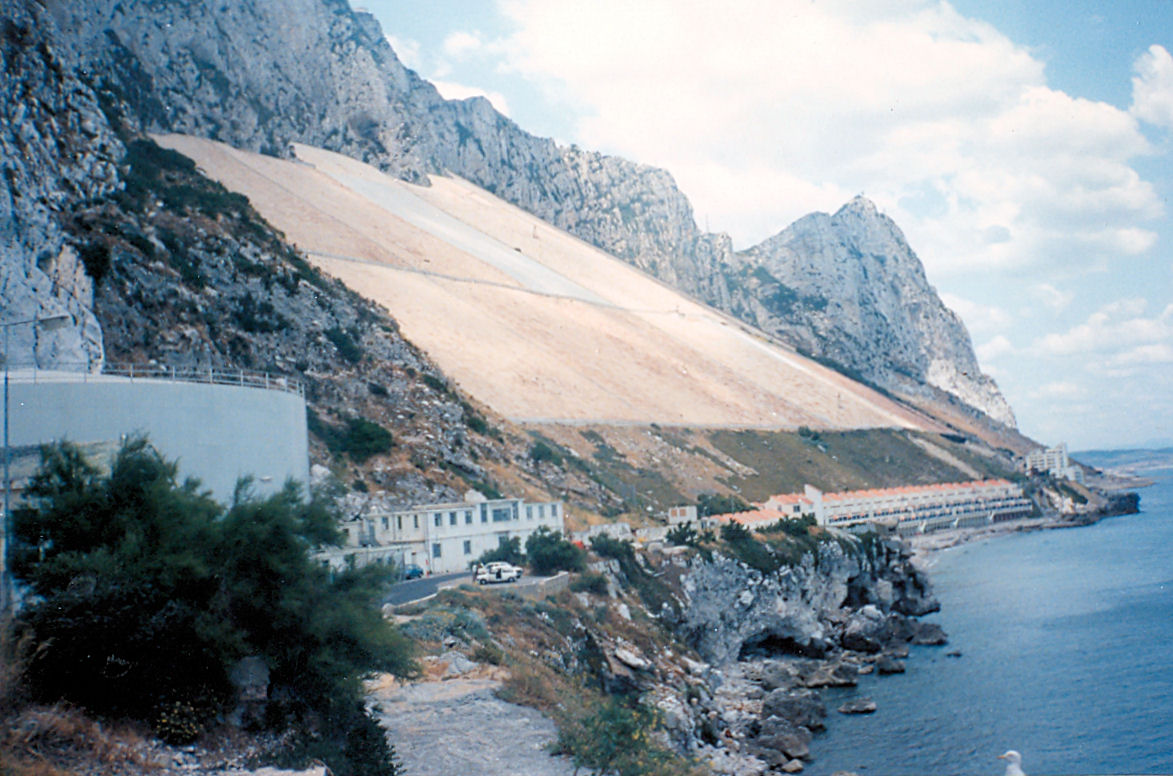
English: A significant proportion of Gibraltar's water is obtained from sloping rock catchments on the Rock. At the foot of the slopes, collecting channels drain into pipes which lead to tanks excavated inside the rock. |
| Date | |
| Source |
Rainwater Harvesting in Gibraltar - 1992.
|
| Author | Jim Linwood |
Licensing
This file is licensed under the Creative Commons Attribution 2.0 Generic license.
- You are free:
- to share – to copy, distribute and transmit the work
- to remix – to adapt the work
- Under the following conditions:
- attribution – You must give appropriate credit, provide a link to the license, and indicate if changes were made. You may do so in any reasonable manner, but not in any way that suggests the licensor endorses you or your use.
| This image, originally posted to Flickr, was reviewed on February 20, 2010 by the administrator or reviewer File Upload Bot (Magnus Manske), who confirmed that it was available on Flickr under the stated license on that date. |
File history
Click on a date/time to view the file as it appeared at that time.
| Date/Time | Thumbnail | Dimensions | User | Comment | |
|---|---|---|---|---|---|
| current | 22:10, 20 February 2010 | | 1,173 × 776 (208 KB) | File Upload Bot (Magnus Manske) | {{Information |Description=A significant proportion of Gibraltar's water is obtained from sloping rock catchments on the Rock. At the foot of the slopes, collecting channels drain into pipes which lead to tanks excavated inside the rock. |Source=[http:/ |
File usage
The following 9 pages use this file:
- Environmental resource management
- Great Gibraltar Sand Dune
- Rainwater harvesting
- Water supply and sanitation in Gibraltar
- Wikipedia:Did you know/Statistics/Monthly DYK pageview leaders/2013
- Wikipedia:GLAM/GibraltarpediA/Images/Geography
- Wikipedia:Main Page history/2013 September 30
- Wikipedia:Recent additions/2013/September
- Template:Did you know nominations/Water supply and sanitation in Gibraltar
Global file usage
The following other wikis use this file:
- Usage on ca.wikipedia.org
- Usage on cs.wikipedia.org
- Usage on de.wikipedia.org
- Usage on es.wikipedia.org
- Usage on fr.wikipedia.org
- Usage on hr.wikipedia.org
- Usage on no.wikipedia.org
- Usage on sl.wikipedia.org
- Usage on tr.wikipedia.org
- Usage on uz.wikipedia.org