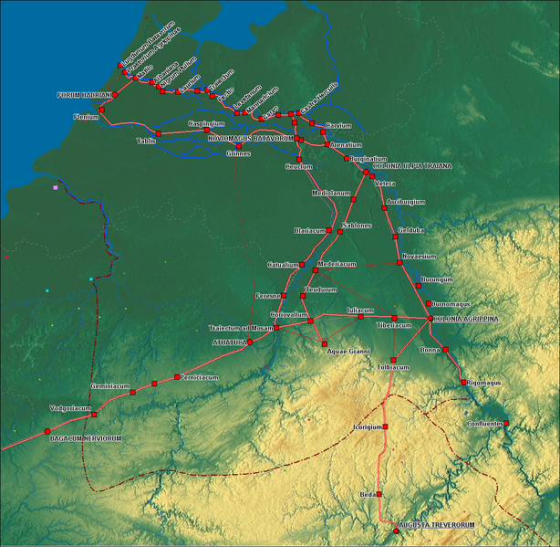
File:Germania inferior roads towns.png
Appearance

Size of this preview: 614 × 599 pixels. Other resolutions: 246 × 240 pixels | 492 × 480 pixels | 787 × 768 pixels | 1,162 × 1,134 pixels.
Original file (1,162 × 1,134 pixels, file size: 1.83 MB, MIME type: image/png)
File history
Click on a date/time to view the file as it appeared at that time.
| Date/Time | Thumbnail | Dimensions | User | Comment | |
|---|---|---|---|---|---|
| current | 23:06, 16 September 2009 |  | 1,162 × 1,134 (1.83 MB) | Hans Erren | road Forum Hadriani Noviomagus edited, location of Tablis and Caspingium moved, symbology and labels modified |
| 20:17, 13 September 2009 |  | 1,162 × 1,132 (1.84 MB) | Hans Erren | Added province boundaries from Westermann Grosser Atlas zur Weltgeschichte 1972 | |
| 13:56, 13 September 2009 |  | 1,155 × 1,131 (1.83 MB) | Hans Erren | {{Information |Description={{en|1=Roads and Towns in Germania Inferior}} {{nl|1=Wegen en Nerderzettingen in Germania Inferior}} |Source=Own work by uploader |Author=Hans Erren |Date= |Permission= |other_versions= }} == Summary == {{Inf |
File usage
The following 4 pages use this file:
Global file usage
The following other wikis use this file:
- Usage on az.wikipedia.org
- Usage on de.wikipedia.org
- Usage on el.wikipedia.org
- Usage on eo.wikipedia.org
- Usage on es.wikipedia.org
- Usage on et.wikipedia.org
- Usage on fr.wikipedia.org
- Usage on hr.wikipedia.org
- Usage on it.wikipedia.org
- Usage on kk.wikipedia.org
- Usage on ko.wikipedia.org
- Usage on la.wikipedia.org
- Usage on mk.wikipedia.org
- Usage on nl.wikipedia.org
- Usage on pcd.wikipedia.org
- Usage on pl.wikipedia.org
- Usage on pt.wikipedia.org
- Usage on ro.wikipedia.org
- Usage on ru.wikipedia.org
- Usage on sq.wikipedia.org
- Usage on uk.wikipedia.org


