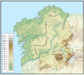
File:Galicia Topo.svg
Appearance

Size of this PNG preview of this SVG file: 671 × 600 pixels. Other resolutions: 269 × 240 pixels | 537 × 480 pixels | 859 × 768 pixels | 1,146 × 1,024 pixels | 2,292 × 2,048 pixels | 1,035 × 925 pixels.
Original file (SVG file, nominally 1,035 × 925 pixels, file size: 2.73 MB)
File history
Click on a date/time to view the file as it appeared at that time.
| Date/Time | Thumbnail | Dimensions | User | Comment | |
|---|---|---|---|---|---|
| current | 19:34, 22 November 2010 |  | 1,035 × 925 (2.73 MB) | Edoarado | Cambiado "Macizo de Manzaneda" por "Macizo Central Ourensán" |
| 10:22, 18 November 2010 |  | 1,035 × 925 (2.73 MB) | Edoarado | Texto convertido a trazo. | |
| 10:14, 18 November 2010 |  | 1,035 × 925 (2.59 MB) | Edoarado | {{Information |Description={{en|1=Topographical map from Galicia (Spain) with mountain names. Include mayor rivers and borders.}} {{es|1=Mapa topográfico de Galicia con los nombres de las montañas principales. Incluye los ríos principales y las fronter |
File usage
The following 2 pages use this file:
Global file usage
The following other wikis use this file:
- Usage on an.wikipedia.org
- Usage on arz.wikipedia.org
- Usage on cs.wikipedia.org
- Usage on es.wikipedia.org
- Usage on eu.wikipedia.org
- Usage on fr.wikipedia.org
- Usage on gl.wikipedia.org
- Usage on hu.wikipedia.org
- Usage on pt.wikipedia.org
- Usage on www.wikidata.org
- Usage on zh.wikipedia.org

