Jump to content

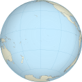
File:French Polynesia (orthographic projection, yellowblue).svg

Page contents not supported in other languages.
This is a file from the Wikimedia Commons
From Wikipedia, the free encyclopedia

Original file (SVG file, nominally 501 × 501 pixels, file size: 291 KB)

Summary

Description
English: A map of the hemisphere centred on French Polynesia, using an orthographic projection, created using gringer's Perl script with Natural Earth Data (1:50000 resolution, simplified to 0.01px).
Français : Représentation du globe terrestre centrée sur la Polynésie française. Carte en projection orthographique, générée par le script de Gringer en langage Perl avec les données du site www.naturalearthdata.com. Résolution 1:50000, simplifiée à 0,01 pixel.
Date
Source Own work
Author Gringer
Other versions

Grey-green version

SVG
InfoField
 
W3C-validity not checked.
 
This W3C-unspecified vector image was created with Inkscape…important .
Camera location17° 30′ 00″ S, 149° 30′ 00″ W  Heading=0° Kartographer map based on OpenStreetMap.View this and other nearby images on: OpenStreetMapinfo

Licensing

Public domain I, the copyright holder of this work, release this work into the public domain. This applies worldwide.
In some countries this may not be legally possible; if so:
I grant anyone the right to use this work for any purpose, without any conditions, unless such conditions are required by law.

Captions

Add a one-line explanation of what this file represents

Items portrayed in this file

depicts

6 October 2010

17°30'S, 149°30'W

heading: 0 degree

File history

Click on a date/time to view the file as it appeared at that time.

Date/TimeThumbnailDimensionsUserComment
current17:38, 27 April 2011Thumbnail for version as of 17:38, 27 April 2011501 × 501 (291 KB)SémhurTry to see the map
12:54, 5 October 2010Thumbnail for version as of 12:54, 5 October 2010550 × 550 (744 KB)Gringer{{Information |Description={{en|1=A map of the hemisphere centred on French Polynesia, using an orthographic projection, created using gringer's Perl script with Natural Earth Data (1:50000 resolution, simplified to 0.25px). }} |Source={{own}} |Author=[[U

The following page uses this file:

Global file usage

The following other wikis use this file: