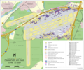
File:Frankfurt-Main Airport Map EN.png
Appearance

Size of this preview: 715 × 600 pixels. Other resolutions: 286 × 240 pixels | 572 × 480 pixels | 916 × 768 pixels | 1,221 × 1,024 pixels | 2,253 × 1,890 pixels.
Original file (2,253 × 1,890 pixels, file size: 1.52 MB, MIME type: image/png)
File history
Click on a date/time to view the file as it appeared at that time.
| Date/Time | Thumbnail | Dimensions | User | Comment | |
|---|---|---|---|---|---|
| current | 19:48, 30 April 2016 |  | 2,253 × 1,890 (1.52 MB) | Thoroe | optipng |
| 19:44, 30 April 2016 |  | 2,253 × 1,890 (2.03 MB) | Thoroe | upd | |
| 11:11, 28 April 2012 |  | 1,623 × 1,361 (1.39 MB) | Thoroe | Car park at "The Squaire" | |
| 16:01, 18 October 2011 |  | 1,623 × 1,361 (1.38 MB) | Thoroe | Runway Northwest completed | |
| 21:36, 19 August 2010 |  | 1,623 × 1,361 (1.39 MB) | Thoroe | {{Information |Description={{en|1=Map of Frankfurt Airport, Germany (EN)}} {{de|1=Lageplan des Flughafen Frankfurt am Main (EN)}} |Source={{own}}{{Adobe Illustrator}} *[http://w |
File usage
The following page uses this file:
Global file usage
The following other wikis use this file:
- Usage on ast.wikipedia.org
- Usage on es.wikipedia.org
- Usage on hy.wikipedia.org
- Usage on ro.wikipedia.org


