
File:France map Lambert-93 with regions and departments-occupation Belgium.png

Size of this preview: 632 × 600 pixels. Other resolutions: 253 × 240 pixels | 506 × 480 pixels | 809 × 768 pixels | 1,079 × 1,024 pixels | 1,996 × 1,894 pixels.
Original file (1,996 × 1,894 pixels, file size: 975 KB, MIME type: image/png)
| This is a file from the Wikimedia Commons. Information from its description page there is shown below. Commons is a freely licensed media file repository. You can help. |
Summary
| Description |
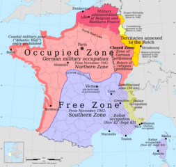
English: Occupation zones of France, Belgium and Luxembourg during the Second World War |
| Date | |
| Source | Own work |
| Author | Victor falk - based on File:France map Lambert-93 with regions and departments-occupation.svg |
Licensing
I, the copyright holder of this work, hereby publish it under the following license:
This file is licensed under the Creative Commons Attribution-Share Alike 3.0 Unported license.
- You are free:
- to share – to copy, distribute and transmit the work
- to remix – to adapt the work
- Under the following conditions:
- attribution – You must give appropriate credit, provide a link to the license, and indicate if changes were made. You may do so in any reasonable manner, but not in any way that suggests the licensor endorses you or your use.
- share alike – If you remix, transform, or build upon the material, you must distribute your contributions under the same or compatible license as the original.
File history
Click on a date/time to view the file as it appeared at that time.
| Date/Time | Thumbnail | Dimensions | User | Comment | |
|---|---|---|---|---|---|
| current | 23:40, 13 June 2014 | | 1,996 × 1,894 (975 KB) | Victor falk~commonswiki | 1) Corrected misplaced Grenoble not in DMZ 2) Coloured annexed yellow |
| 05:55, 25 May 2014 |  | 1,996 × 1,894 (981 KB) | Victor falk~commonswiki | alsace-lorraine | |
| 12:08, 24 May 2014 |  | 1,996 × 1,894 (974 KB) | Victor falk~commonswiki | luxembourg | |
| 06:25, 23 May 2014 |  | 1,996 × 1,894 (856 KB) | Victor falk~commonswiki | User created page with UploadWizard |
File usage
The following 2 pages use this file:
Global file usage
The following other wikis use this file:
- Usage on fa.wikipedia.org
- Usage on fr.wikipedia.org
- Usage on id.wikipedia.org
- Usage on ms.wikipedia.org
- Usage on no.wikipedia.org
- Usage on pt.wikipedia.org