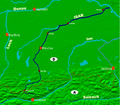
File:Fluss lage isar.PNG
Appearance

Size of this preview: 686 × 600 pixels. Other resolutions: 274 × 240 pixels | 549 × 480 pixels | 878 × 768 pixels | 1,212 × 1,060 pixels.
Original file (1,212 × 1,060 pixels, file size: 482 KB, MIME type: image/png)
File history
Click on a date/time to view the file as it appeared at that time.
| Date/Time | Thumbnail | Dimensions | User | Comment | |
|---|---|---|---|---|---|
| current | 11:11, 18 February 2006 |  | 1,212 × 1,060 (482 KB) | Omnidom 999~commonswiki | {{Information| |Description = Zusehen ist die Lage des Flusses Isar in Südbayern |Source = selbst gemacht mit dem Programm MAP-CREATOR |Date = 18.02.2006 |Author = Niklas Dehne |Permission = |other_versions = }} |
File usage
The following page uses this file:
Global file usage
The following other wikis use this file:
- Usage on an.wikipedia.org
- Usage on ar.wikipedia.org
- Usage on bg.wikipedia.org
- Usage on de.wikipedia.org
- Usage on fi.wikipedia.org
- Usage on it.wikipedia.org
- Usage on nl.wikipedia.org
- Usage on pms.wikipedia.org
- Usage on pt.wikipedia.org
- Usage on vi.wikipedia.org
- Usage on zh.wikipedia.org
