File:Falls map 9 det.jpeg

Original file (941 × 1,187 pixels, file size: 359 KB, MIME type: image/jpeg)
| Description |
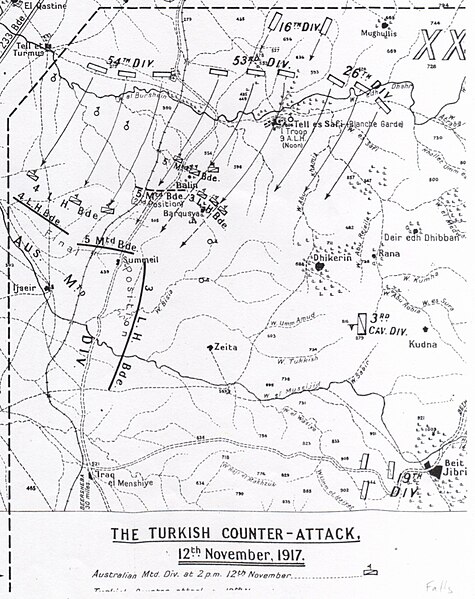
Battle of Mughar Ridge - Ottoman counterattack on 12 November 1917; Map shows the positions of the Australian Mounted Division before, during and at the end of 12 November. Also identified are the Ottoman divisions involved and the direction of their attack. | ||
|---|---|---|---|
| Source |
Authors: Falls, Cyril with G. MacMunn, A.F. Beck Title: Military Operations Egypt & Palestine from June 1917 to the end of the War: History of the Great War Based on Official Documents by Direction of the Historical Section of the Committee of Imperial Defence. 2 Part 1. Published: London: HM Stationery Office. Date: 1930 | ||
| Date | |||
| Author |
| ||
| Permission (Reusing this file) |
See below.
|
| This work created by the United Kingdom Government is in the public domain.
This is because it is one of the following:
HMSO has declared that the expiry of Crown Copyrights applies worldwide (ref: HMSO Email Reply) |  |
 | This file is a candidate to be copied to Wikimedia Commons.
Any user may perform this transfer; refer to Wikipedia:Moving files to Commons for details. If this file has problems with attribution, copyright, or is otherwise ineligible for Commons, then remove this tag and DO NOT transfer it; repeat violators may be blocked from editing. Other Instructions
| ||
| |||
File history
Click on a date/time to view the file as it appeared at that time.
| Date/Time | Thumbnail | Dimensions | User | Comment | |
|---|---|---|---|---|---|
| current | 06:17, 24 November 2010 |  | 941 × 1,187 (359 KB) | RoslynSKP (talk | contribs) | Authors: Falls, Cyril with G. MacMunn, A.F. Beck Title: Military Operations Egypt & Palestine from June 1917 to the end of the War: History of the Great War Based on Official Documents by Direction of the Historical Section of the Committee of Imperial |
You cannot overwrite this file.
File usage
The following 2 pages use this file:
