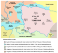
File:Eyalet of temesvar1699.png
Appearance

Size of this preview: 615 × 599 pixels. Other resolutions: 246 × 240 pixels | 493 × 480 pixels | 1,010 × 984 pixels.
Original file (1,010 × 984 pixels, file size: 113 KB, MIME type: image/png)
File history
Click on a date/time to view the file as it appeared at that time.
| Date/Time | Thumbnail | Dimensions | User | Comment | |
|---|---|---|---|---|---|
| current | 21:11, 14 September 2013 |  | 1,010 × 984 (113 KB) | WikiEditor2004 | aesthetics |
| 20:20, 5 September 2013 |  | 1,010 × 984 (117 KB) | WikiEditor2004 | corrections | |
| 16:59, 30 September 2011 |  | 1,015 × 984 (117 KB) | WikiEditor2004 | correction | |
| 12:42, 29 September 2011 |  | 1,015 × 984 (117 KB) | WikiEditor2004 | some corrections | |
| 21:04, 22 March 2009 |  | 1,015 × 984 (120 KB) | WikiEditor2004 | ||
| 12:02, 20 March 2009 |  | 1,015 × 936 (121 KB) | WikiEditor2004 | ||
| 02:15, 20 March 2009 |  | 1,015 × 894 (111 KB) | WikiEditor2004 | map of the Eyalet of Temesvar and Military Frontier in 1699 (self made) {{PD-self}} Category:Maps of the history of Romania Category:Maps of the history of Serbia Category:Maps of the history of Vojvodina |
File usage
The following 8 pages use this file:
Global file usage
The following other wikis use this file:
- Usage on da.wikipedia.org
- Usage on de.wikipedia.org
- Usage on el.wikipedia.org
- Usage on et.wikipedia.org
- Usage on fa.wikipedia.org
- Usage on gl.wikipedia.org
- Usage on he.wikipedia.org
- Usage on hr.wikipedia.org
- Usage on ja.wikipedia.org
- Usage on lt.wikipedia.org
- Usage on mk.wikipedia.org
- Usage on nn.wikipedia.org
- Usage on no.wikipedia.org
- Usage on pnb.wikipedia.org
- Usage on pt.wikipedia.org
- Usage on ro.wikipedia.org
- Usage on ru.wikipedia.org
- Usage on sh.wikipedia.org
- Usage on sk.wikipedia.org
- Usage on sl.wikipedia.org
- Usage on th.wikipedia.org
- Usage on tr.wikipedia.org
- Usage on tt.wikipedia.org
- Usage on ur.wikipedia.org
- Usage on vi.wikipedia.org
