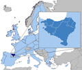
File:Euskal Herria Europa.png
Appearance

Size of this preview: 698 × 600 pixels. Other resolutions: 280 × 240 pixels | 559 × 480 pixels | 815 × 700 pixels.
Original file (815 × 700 pixels, file size: 37 KB, MIME type: image/png)
File history
Click on a date/time to view the file as it appeared at that time.
| Date/Time | Thumbnail | Dimensions | User | Comment | |
|---|---|---|---|---|---|
| current | 14:54, 27 December 2022 |  | 815 × 700 (37 KB) | Iktsokh | Better shading |
| 12:19, 20 April 2015 |  | 815 × 700 (65 KB) | Zorion | Improvement | |
| 12:38, 18 April 2011 |  | 815 × 700 (59 KB) | Zorion | Turtzioz and Trebiñu out | |
| 20:44, 27 December 2010 |  | 815 × 700 (61 KB) | Zorion | Improvement | |
| 23:20, 21 December 2010 |  | 815 × 700 (61 KB) | Zorion | {{Information |Description={{fr|1=Le Pays basque en Europe}} |Source={{own}} |Author={{User:Zorion/creditimage}} |Date=2010-12-21 |Permission= |other_versions= }} Category:Maps of the Basque Country |
File usage
The following 3 pages use this file:
Global file usage
The following other wikis use this file:
- Usage on af.wikipedia.org
- Usage on an.wikipedia.org
- Usage on be-tarask.wikipedia.org
- Usage on bg.wikipedia.org
- Usage on br.wikipedia.org
- Usage on ca.wikinews.org
- Usage on cy.wikipedia.org
- Usage on de.wikipedia.org
- Usage on el.wikipedia.org
- Usage on el.wiktionary.org
- Usage on eo.wikipedia.org
- Usage on es.wikipedia.org
- Usage on et.wikipedia.org
- Usage on eu.wikipedia.org
- Usage on ext.wikipedia.org
- Usage on fa.wikipedia.org
- Usage on fi.wikipedia.org
- Usage on fr.wikipedia.org
- Usage on fr.wiktionary.org
- Usage on gd.wikipedia.org
- Usage on gl.wikipedia.org
- Usage on gv.wikipedia.org
- Usage on he.wikipedia.org
- Usage on id.wikipedia.org
- Usage on io.wikipedia.org
- Usage on it.wikipedia.org
- Usage on ja.wikipedia.org
View more global usage of this file.


