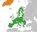
File:European Union Greenland Locator.svg
Appearance

Size of this PNG preview of this SVG file: 800 × 406 pixels. Other resolutions: 320 × 162 pixels | 640 × 325 pixels | 1,024 × 520 pixels | 1,280 × 650 pixels | 2,560 × 1,300 pixels | 2,754 × 1,398 pixels.
Original file (SVG file, nominally 2,754 × 1,398 pixels, file size: 1.05 MB)
File history
Click on a date/time to view the file as it appeared at that time.
| Date/Time | Thumbnail | Dimensions | User | Comment | |
|---|---|---|---|---|---|
| current | 10:21, 24 January 2022 |  | 2,754 × 1,398 (1.05 MB) | Saftorangen | use BlankMap-World.svg as template to show all affected areas |
| 09:38, 27 March 2020 |  | 1,981 × 1,701 (641 KB) | Hogweard | Update | |
| 18:21, 29 July 2014 |  | 2,047 × 1,720 (830 KB) | Masterdeis | +Croatia | |
| 14:17, 2 September 2010 |  | 2,047 × 1,720 (870 KB) | Alvaro1984 18 | {{Information |Description={{en|1=The European Union and Greenland}} |Source=*File:European_Union_Israel_Locator.svg |Date=2010-09-02 14:15 (UTC) |Author=*File:European_Union_Israel_Locator.svg: Ssolbergj *derivative work: ~ | |
| 23:12, 14 May 2010 |  | 940 × 415 (1.54 MB) | CGN2010 | {{Information |Description=European Union - Greenland locator map |Source={{own}} |Date=2010-05-15 |Author={{own}} |Permission={{PD-self}} |other_versions= }} Category:Bilateral maps of the European Union Category:maps of Greenland |
File usage
The following page uses this file:
Global file usage
The following other wikis use this file:
- Usage on da.wikipedia.org
- Usage on es.wikipedia.org
- Usage on et.wikipedia.org
- Usage on fr.wikipedia.org
- Usage on nl.wikipedia.org
- Usage on ru.wikipedia.org
- Usage on uk.wikipedia.org
- Usage on www.wikidata.org
- Usage on zh.wikipedia.org
