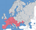
File:Europe Lepomis map.png
Appearance

Size of this preview: 719 × 600 pixels. Other resolutions: 288 × 240 pixels | 576 × 480 pixels | 921 × 768 pixels | 1,266 × 1,056 pixels.
Original file (1,266 × 1,056 pixels, file size: 389 KB, MIME type: image/png)
File history
Click on a date/time to view the file as it appeared at that time.
| Date/Time | Thumbnail | Dimensions | User | Comment | |
|---|---|---|---|---|---|
| current | 08:30, 26 December 2022 |  | 1,266 × 1,056 (389 KB) | Iktsokh | More correct visualization of the dividing line on the territory of the Caucasus Range |
| 08:04, 20 September 2018 |  | 1,266 × 1,056 (372 KB) | Ykvach | Including of new data | |
| 15:49, 24 November 2016 |  | 1,266 × 1,056 (372 KB) | Ykvach | Some details are corrected | |
| 14:26, 23 November 2016 |  | 1,266 × 1,056 (372 KB) | Ykvach | User created page with UploadWizard |
File usage
The following page uses this file:
Global file usage
The following other wikis use this file:
- Usage on cs.wikipedia.org
- Usage on de.wikipedia.org
- Usage on eu.wikipedia.org
- Usage on gl.wikipedia.org
- Usage on no.wikipedia.org
- Usage on pl.wikipedia.org
- Usage on ru.wikipedia.org
- Usage on uk.wikipedia.org
