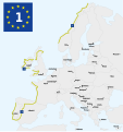
File:EuroVelo Route 1.svg
Appearance

Size of this PNG preview of this SVG file: 563 × 599 pixels. Other resolutions: 225 × 240 pixels | 451 × 480 pixels | 721 × 768 pixels | 962 × 1,024 pixels | 1,924 × 2,048 pixels | 652 × 694 pixels.
Original file (SVG file, nominally 652 × 694 pixels, file size: 322 KB)
File history
Click on a date/time to view the file as it appeared at that time.
| Date/Time | Thumbnail | Dimensions | User | Comment | |
|---|---|---|---|---|---|
| current | 20:25, 19 November 2020 |  | 652 × 694 (322 KB) | TouN | Reverted to version as of 20:19, 19 November 2020 (UTC) |
| 20:24, 19 November 2020 |  | 652 × 694 (322 KB) | TouN | Add section between Sagres & Caminha (Portugal) - v2 | |
| 20:19, 19 November 2020 |  | 652 × 694 (322 KB) | TouN | Add section between Sagres & Caminha (Portugal) | |
| 19:18, 8 January 2013 |  | 652 × 694 (324 KB) | Rbrausse | {{Information |Description ={{en|1=EuroVelo Route 1 (as of May 2009)}} |Source =File:EuroVelo map.jpg, http://www.eurovelo.org/routes/ and http://www.ecf.com/wp-content/uploads/2011/09/EuroVelo-The_European_cycle_route_network-May2009.p... |
File usage
The following 2 pages use this file:
Global file usage
The following other wikis use this file:
- Usage on de.wikipedia.org
- Usage on eo.wikipedia.org
- Usage on es.wikipedia.org
- Usage on eu.wikipedia.org
- Usage on fr.wikipedia.org
- Usage on hu.wikipedia.org
- Usage on is.wikipedia.org
- Usage on it.wikipedia.org
- Usage on nl.wikipedia.org
- Usage on ru.wikipedia.org
- Usage on www.wikidata.org

