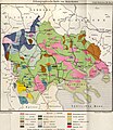
File:Ethnographische Karte von Makedonien (1899).jpg
Appearance

Size of this preview: 520 × 600 pixels. Other resolutions: 208 × 240 pixels | 416 × 480 pixels | 666 × 768 pixels | 888 × 1,024 pixels | 1,776 × 2,048 pixels | 3,065 × 3,535 pixels.
Original file (3,065 × 3,535 pixels, file size: 1.14 MB, MIME type: image/jpeg)
File history
Click on a date/time to view the file as it appeared at that time.
| Date/Time | Thumbnail | Dimensions | User | Comment | |
|---|---|---|---|---|---|
| current | 18:13, 20 November 2022 |  | 3,065 × 3,535 (1.14 MB) | Ασμοδαίος | restoring previous version -- the new version uploaded by Gyalu22 renders some groups (such as the Kutzovlachen mohamed. and the Turken mohamed.) practically indistinguishable |
| 09:24, 20 November 2022 |  | 3,065 × 3,535 (4.66 MB) | Gyalu22 | levels | |
| 21:48, 29 April 2008 |  | 3,065 × 3,535 (1.14 MB) | Olahus | {{Information |Description=Ethnic map of Macedonia |Source=Deutsche Rundschau für Geographie und Statistik |Date=1892 |Author=own scan |Permission= |other_versions= }} Category:Maps of ethnic groups in Bulgaria [[Category:Maps of ethnic groups in Gr |
File usage
The following 8 pages use this file:
Global file usage
The following other wikis use this file:
- Usage on bg.wikipedia.org
- Usage on de.wikipedia.org
- Usage on el.wikipedia.org
- Usage on fr.wikipedia.org
- Usage on fr.wiktionary.org
- Usage on hr.wikipedia.org
- Usage on it.wikipedia.org
- Usage on mk.wikipedia.org
- Usage on ro.wikipedia.org
- Usage on ru.wikipedia.org
- Usage on sl.wikipedia.org
- Usage on sq.wikipedia.org
- Usage on sr.wikipedia.org
- Usage on uk.wikipedia.org
